 Acocks Green History Society
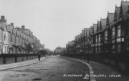
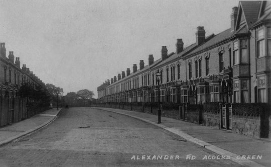
Alexander Road
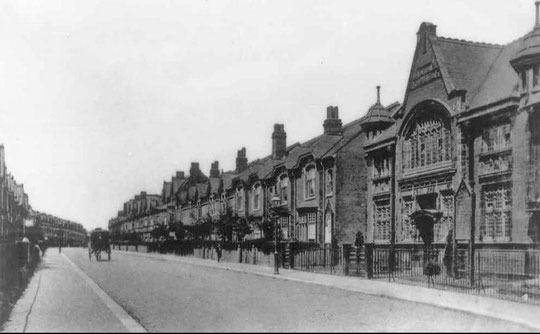
Alexander Road was developed during the Edwardian period, together with other nearby roads. Most of the development took place between 1903 and 1906, with more houses being built by 1908/9. However, numbers 33 and 35 are postwar replacements.
A letter in the Birmingham Daily Mail in February 1905 stated that the road had been inhabited for nearly two years, and that the road had not yet been adopted and was in a terrible state. It was part of a land sale by the Greswolde-Williams family. There are some interesting comparisons to be made with Arden Road, much of which was developed a few years earlier. A local builder, Williams and Boddy, was responsible for the late Victorian and Edwardian buildings on Arden Road (and also Greswolde Park Road and a short stretch of the Warwick Road). Although there are several styles of homes, they are all Williams and Boddy who were clearly mindful of market trends. When you come to Alexander Road, although it appears at first glance to be terraced uniformity, there are many different styles of house, sometimes after only a few numbers. There is one longer row developed by a single builder. The houses are also smaller than those on Edwardian Arden Road.
What appears to have happened is that the land was sold in small plots, and in many cases was probably bought by businessmen looking to make money from investment in property rather than to live in the houses themselves. Also it appears that ownership was in some cases in the hands of women, giving them a degree of financial independence and lifestyle choice. Maybe fathers passed on money to their daughters, who were advised to invest in property.
In the 1906 Poor Rates records, there were 171 properties listed, in 1912 there were 215, and in 1913 there were 216. Of the properties present in 1906, less than 15% were occupied by the same people in 1913. Even between 1911 and 1913, the same people were in residence in only 53.5% of the houses. Whoever owned the properties, there was frequent turnover of occupiers, perhaps due to changes in jobs, business failures, or newer properties appearing elsewhere.
Numbers 235 to 237 were not present in the 1913 rate book, number 239 was. Numbers 113 to 125, 151 to 165, 88 to 98 and 154 to 198 were not there in 1906, but nearly all were listed in the 1909 directory. Chas. Hougham, a well known Birmingham builder, was involved with at least numbers 113 to 125 and 154 to 198.
Owner occupiers were 11% of the total in 1906, 6.5% in 1912, and only 5% in 1913. So initial owners sold up or rented out, with some perhaps taking a profit from their initial investment.
In 1906, 22 properties were owned by Wyatt (? Myatt)/Smith, 19 by Bayliss, 16 by Jennings/Smith, 14 by Cottrell (/ Cotterill), 12 by Garfield, and 12 by Green. 20 other people had fewer than 10 properties.
In 1912, Dolan had 23 (numbers 154 to 198 were not built by 1906), Wyatt had 22, Cotterill had 20, Bayliss had 15, Garfield had 12, and Mould had 11 (these are ex-Jennings, who has kept the other 5), and Green had sold up. There were now 40 owners with fewer than 10 properties.
In 1913, Dolan had 23, Wyatt had 22, Cotterill had 20, Bayliss had 15, Garfield had 12, and Mould 11. There were now 42 owners with fewer than 10 properties.
We have not been able to identify Mrs J Dolan locally, nor T. Myatt/Wyatt, W. Cotterill, H. Mould or J. Garfield. J Baylis was a retired house builder in the 1911 census, living at 249 Alexander Road.
The late Julia Larden, an immensely influential figure in Acocks Green, wrote a piece about Albert Washbourne, property owner and speculator in Alexander Road. It is reproduced in part here with permission. Some editing has been done.
According to census records there was only one ‘A. Washbourne’ living in Erdington in 1901: Albert Washbourne, 51, head of the family at Blythe House, Sutton Road, Erdington. According to Google Maps the distance between Sutton Road and this Church is approximately 0.4 miles, or eight minutes walking time. Albert Washbourne is interesting to me, and of some slight interest to Acocks Green more generally, because of the following document amongst the title deeds for my home: 143 Alexander Road, Acocks Green.
The first part of this document, which appears to have been originally drawn up in 1903, but re-copied and expanded upon in the 1950s, reads (copied verbatim from the original typescript) as follows:
ABSTRACT TITLE of Whitall Properties (Birmingham) Ltd to leasehold property 125/145 Alexander Road. Acocks Green in the City of Birmingham
‘Building lease of this dt. and betwn Albert Washbourne of Blythe House Erdington in the Cy of Warwick Gentleman (thrar called “The lessor” wch expression shld include his hrs and assns. Where the context so admitd) of this one pt and William Cotterill of 11 Birchfield Road Aston Juxta Birmingham in the Cy of Warwick Plumber (thrnar called “the Lessee” wch expression shld include his exors admonre and assns. Where the context so admtd) of or pt IT WAS WITNESSED that in conson of £300:0:0 pd. & c. rect &c and also of the rent thrby reserved and the covenants on the part of the Lessee thrnar contd the Lessor thrby DEMISED unto the Lessee
All that pce of land site at Stockfield in the Parish of Yardley in the Cy of Worcester fronting on the Northern side of thereof to Alexander Rd there and abutting at the back thereof upon land of the Great Western Railway Company wch sd pce of land contained in front next Alexander Rd afsd 59 yds. 1 ft and 3 ins or thrabts and contd on each side thereof 36 yds. And 6 ins or thrabts and in the whole 2149 sq. yrds or thrabts AND ALSO ALL THOSE 4 partly erected messes or swlghses then standing on the ad pce of land and site frontg Alexander Rd afsd wch sd pcs of land is for the ppses of identity deltd in the plan dranw on the margin of those prests and thrn cold pink Except all mines and minerals under the sd pce of land
TO HOLD the same with the appts (except as afsd) unto the Lessee for the term of 99 years to be computed from the 29th Sept, 1903 YIELDING AND PAYING threfor yrly during the sd term and so in proportion for any less time than a year the rent of £28.:10:0 to be paid without deduction (except for Landlords ppty tax) by equal half-yrly pymts on the 25th March and the 29th Sept, the first of such pymts to be md on the 25th March 1905
COVENANTS by Lessee with Lessor:-
To py sd rent
To pay all rates taxes assessments &c
To complete fit for habitation at his own expense the sd 4 partly erected messes or dwlghses with proper and sufficient outhouses and conveniences thrto in accordance with the plans which have bn approved by the Lessor
To build at the like expense upon the sd pce of land 6 and not more than 6 other good and substantial messes or dwlghses with proper and sufficient outhouses and conveniences thrto upon a site and according to plans to be first approved in writing with by the Lessor and wld build such mentd messes within 2 yrs from the date thereof …
It goes on (p. 2) to give a great many conditions about repairs and safety before instructing Mr Cotterill that he must:
keep and maintain one half of Alexander Road […] until sch road should be taken over and adopted by the Yardley District Council as a public highway or street.
(The map on my document actually appears as an attachment, presumably added as such in the 1950s. Below is a scanned version:

In other words Albert Washbourne purchased a piece of land in Alexander Road, Acocks Green, in order to build ten properties: numbers 127-145. Apart from (probably) being a Baptist and a deacon who was Albert Washbourne and how did he come to be investing in land in order to build properties on the other side of Birmingham?
The 1901 census form tells us, Albert Washbourne was a ‘Draper and House Furnisher who lived with his wife Ann, his three daughters: Gertrude, Beatrice and Gladys and his son Charles John. The house was also occupied by two live-in servants. A newspaper file search reveals two further interesting items of information. In 1892 Albert was robbed at his draper’s shop by of his assistants who was subsequently prosecuted. The story ended up in The Birmingham Daily Post for 7 December 1892.
From this we learn that Albert’s shop was at 220 Aston Road. From another newspaper report, not long afterwards we learn even more about Albert. He announced his candidacy for St. Mary's Ward of the City Council in 1894 for the Liberal Unionist Party. There is also a defence of the services provided by the Council which are now perceived to be under threat by an outsider standing from something called the Ratepayer’s Association.
There was a Baptist presence around this part of Acocks Green by 1903. Did, for example, Albert hear of the land for sale at Alexander Road through his fellow Baptist Church member (and deacon) one Joseph Walker?
After his profitable speculation on numbers 127-145 Alexander Road Albert definitely went up in the world because he had this property built for himself, architect-designed, in 1905: this was Hindecliffe in Four Oaks.
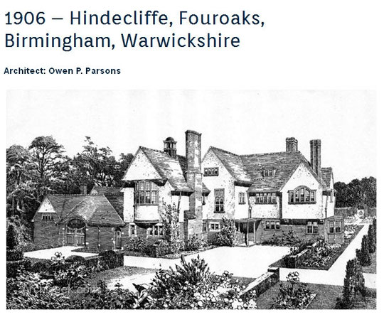
Albert was still living there in 1916, when tragedy struck: the Washbournes of Hindecliffe, Four Oaks, (Albert and Ann) lost their only son Charles John (all these names recorded at Blythe House in Erdington in the 1901 census) at the Battle of the Somme. It is all recorded here in the listings for the Four Oaks War Memorial (Charles John is the tenth name down.)
The full version, with images we have not reproduced here, is at:

There are early non-residential buildings at the Yardley Road end of Alexander Road. The Baptist church and the former Fire Station are covered elsewhere. Firemen lived in Alexander Road from 1926 in numbers 2 and 4. Number 4 hosted an office for Fire and Ambulance services from the 1940s according to directories. The City's Public Assistance Department appears to have been in the 1903 Church Hall at the end of the 1930s. Towards the end of World War One it had been used for making surgical dressings and bandages.
Number 121 was a shop from the 1930s. Number 221 became a madrassa and local prayer house in 1990. There have been a number of planning applications since then, and number 219, previously a house, was an element in expansion proposals in 2014/5, where submissions were rejected, especially due to the potential impact of traffic and parking on other residents. Just beyond there, at number 225, a Territorial Army Cadet Unit was approved in 1991. It is currently known as Alexander Road Platoon ACF (Army Cadet Force).
Earlier we were mentioning houses as an investment. This did not necessarily mean catering for only relatively well-off lower middle-class families. Already in 1906 number 162 was advertised as two apartments, and in 1907 number 79 had been divided as well. However, later, this did not seem to be the case for both. The layouts in the paragraph below comes from voters' lists.
In 1935 number 47 was occupied apparently by three families, and number 53 and number 65 by two. By 1945 number 39 was in two flats, and a flat was mentioned at number 29. Two flats were there in 1949. In the same year there were two units at number 35, and two at number 40. Number 22 had four surnames, but by 1956 only one. By 1957-8 number 235 was in two flats as well, but not in 1960, when number 99 was another number with two flats. by 1962-3 number 123 was also in two flats. By 1965-6 additions to this list were number 37 in five flats, number 41 in two flats, number 91 in three flats, and number 95 in two.
Later Planning Applications were for number 38 to be converted into four flats and a bedsit in 1966, and in the same year for number 88 and 185 to become two flats. In 1969 number 71 was applied for as two flats, and the same applied to number 38 in 1971. In 1983 number 40 was to be two flats, which may indicate a period sometime after 1965-6 as a single-family home again. In 1989 an application was made for number 69 to become new bedsits.
As of June 2023, the situation is as follows, according to a postcode search and the register of houses in multiple occupation (this is likely to be incomplete and liable to change, but is nevertheless a snapshot):
2: at least four flats
4: at least four flats
6: at least two flats
16: Licensed HMO
18: two, possibly three flats
21: six flats
22: two flats
29: two flats
31: four flats at least
32: two flats
35; two units
37: six flats, Licensed HMO
38: possibly five flats
39: two flats
40: at least two flats
41: two units
47: there may be six flats
66: two units
69: a flat is mentioned
75: Licensed HMO
77: six flats
79: six flats
83: Licensed HMO
87: Licensed HMO
88: at least three flats
91: at least three flats
104: Licensed HMO
107: Licensed HMO
111: Licensed HMO
114: four flats
123: two flats
129: Licensed HMO
133: Licensed HMO
151: at least two flats
189: Licensed HMO
191: Licensed HMO
196: Licensed HMO
198: Licensed HMO
210: Licensed HMO
Clearly there is a very wide range of housing needs, apart from that of single-family homes this road was built for in the early years of the 20th century. Earlier voters' lists may also indicate people living in rooms with a resident landlord or landlady, and the rapid turnover of tenants we noted suggests that instability and low incomes are an ever-present phenomenon.

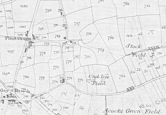
In the mid-nineteenth century, there was still a footpath going across fields 759 and 760 to joining a track bisecting Stock Field. This path is preserved, if offset, from Rookwood Road to between 98 and 102 Alexander Road.

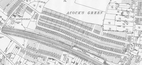
The National Library of Scotland website has 25-inch maps up to the 1930s, and 1:1250 and 1:2500 maps up until 1973. There is also an option to compare Edwardian and current maps of various kinds using a slider. For this use the geo-referenced maps option. This is useful for plotting the exact location of changes.