 Acocks Green History Society
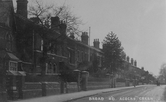
Broad Road
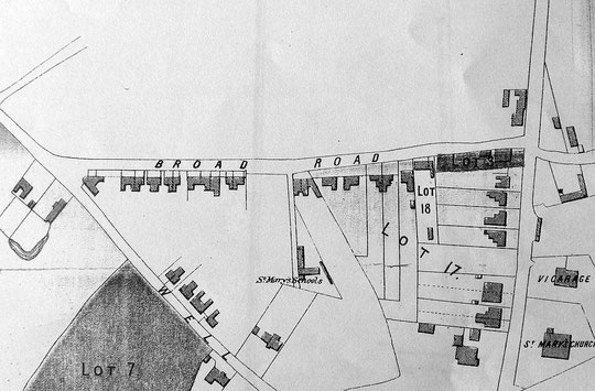
Broad Lane/Road was part of the high ground route through to Yardley church from Fox Hollies Road. The first development was three cottages on land owned since c. 1837 by Benjamin Cook Junior, son of a well-known brassfounder and inventor. These cottages were built between 1853 and 1855: two still stand at the roadside. The 1861 census lists them together with the Warwick Road, although the 1860 directory does allocate them correctly. They were all occupied at the time by skilled craftsmen in the gun trade. Enoch Shufflebotham was a gun polisher, and two other family members were a gun polisher and a gun engraver. In another cottage was James Newton, a gun finisher, and in the third was William Hipkiss, a gun engraver. (The gun trade was also well represented on Sherbourne Road by some of its most senior members).
The three cottages are shown as Lot 18 on the 1875 map below. Two were at Broad Road, and a smaller one was right at the back of Lot number 18, actually behind number 1. Later its gardens stretched across the back of the whole plot containing numbers 1 and 3. It was known as The Cottage, then later as 3A, with access presumably via number 3, and survived until numbers 2-8 Netherfield Gardens were built in 1967.
1, 3 and 3A in 1952 on this NLS map
1, 3 and 2-8 Netherton Gardens in 1970 on this NLS map
James Newton is not listed in 1864, but the other two are. In 1868 both appear again, but also seven new names. However the house names are not given. The 1871 census lists twenty properties, with two unoccupied. Sunnyside (number 11), Oak Cottage (number 13), Francis Villa (number 15), Foxhill Villas (numbers 29 and 31), either number 33 or 35, Albert House (number 37), Clarence Place (number 41 probably, with 43 unoccupied), number 45 (unoccupied), Buckingham Place (number 47), Buckingham House (number 49), and two more, which cannot easily be identified.
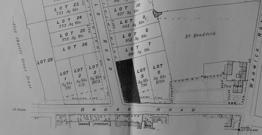
The sale catalogue map below, of 1875, make it possible to identify the twenty houses. Number 15 looks like several. The baker's/confectioner's/coffee house on the Westley Road corner is shown. The 1881 census lists twenty-six houses, with two unoccupied, plus St. Mary's church school, which opened in 1874.
The 1891 census lists twenty-nine properties. Other, tentative dates are Rose Cottage (number 5, 1872), Oscar House (number 7, 1881?), West View (number 9, 1881?), Penrhyn Villas (numbers 17 and 19, by 1896), Wye-Cliff Villas (numbers 21 and 23, by 1896), Oaknest (number 25), and Silverdale/Melverley (number 27, by 1896). The charming development of eight cottages first known as Poplar Avenue (Grove Avenue) appears in the 1901 census.
Dates for houses which appear to have been built in a similar style probably date from the same time: 33 and 35; 39 (The Hollies), 41 and 43 (both Clarence Place); 45, 47 and 49; 51 and 53 (Highland Villas, 1884?), and 55, 57, 59 and 61 (Laurel Villas). The last group is difficult to be sure about.
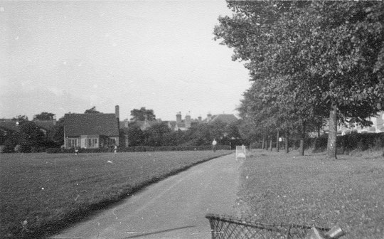
On the other side of road four houses are listed in 1908, but not in 1903: Maple Durham (number 14), The Cottage (number 16), Victoria Cottage/Sudburne/Stagboro (number 18), and Parkside (number 20). Then there is a nurseryman's business. The recreation ground was given as public parkland by Yardley Charity Trustees in 1898. The four houses were numbered 14 to 20 by the mid-1920s.
Numbers 2 to 12 were listed by 1927. Around 1935 a detached and two semis appeared, which were numbered 12 to 16, and 2 to 12 were renumbered as 18 to 28 to Westfield Road, and the four houses and what had become a builder's yard were numbered 32 and 40 to 46.
A gentleman named Lauritz Theodor Hiorth lived at number 31. For a long time described as a merchant, he eventually became the Vice-Consul for Norway. the house has a curious side extension, lower than the main building. Vicki Lee has kindly provided the following information:
"The property was built in 1856 costing £300 using the best materials located in the county of Worcestershire. The side extension became a school room before the school was built in the village and later became a dance studio. I think I’ve found the earliest resident and can answer as to the original nature of it. It seems that Samuel Bloore, early Acocks Green mover and shaker used it to stable his horse and cart. The brickwork around the former entrance has been tied in with the later Victorian change of use. The building at the side is now a self-contained flat."
Numbers 5 to 11 were demolished by the early 1970s. Number 11 had been a dentist's surgery for half a century. Number 13 had become the Grange Social Club c. 1945, having moved from Warwick Road, Tyseley.
Number 15 housed a builder's and then a glazing business from at the latest 1903. Karole Reynolds, who lived in one of the four flats then there, has contacted us about the site from c. 1955 into the 1960s:
"the workshops at the back were partly used by an undertakers business for many years, owned by the Armitt family. The drive-through garage area housed the hearses and the stables were for the horses. There was a carpenters workshop there for making the coffins. Howard (Digs) Andrews was taken on as a leaded light glass apprentice in one of the workshops behind the property at the age of 16 in 1939. The business then known as Premier Paint and Glass was at that time owned by the Armitt family but was bought out by Digs and continued to be run by him until his death in the 1970s. After that business went Mrs Armitt retained control of the property and was our landlady. She collected the rent. I can still visualise the huge back gardens and their formal layout."
The plot was very long, and after the flats were abandoned the grounds were used for anti-social behaviour. In 2011 the site was put up for sale. It was cleared in 2017 after an arson attack: the authorities had confiscated the house and were trying to sell it. The response to that scenario was quick.
Newspaper report on the arson attack
In 2018 the site was replaced by an apartment block, designed in a style sympathetic to its neighbours. The rear part of the long plot has not been redeveloped.
In 1967 Netherfield Gardens was built up, and new numbers 5, 7 and 9 appeared. The Grange Social Club was rebuilt and extended. In 1973 numbers 59 and 61 were renamed Westgreen Court. In 1976 the coffee house was replaced by maisonettes (numbers 65 to 71). In 1982 numbers 2 to 10 were built. Numbers 1A to 1H date from 1985.
The Grange club site acquired a pair of new houses next to number 9 at the front of the site c. 2023, and part of the premises at the back began to be used as a day nursery from January 2023.


The National Library of Scotland website has 25-inch maps up to the 1930s, and 1:1250 and 1:2500 maps up until 1973. There is also an option to compare Edwardian and current maps of various kinds using a slider. For this use the geo-referenced maps option. This is useful for plotting the exact location of changes.