 Acocks Green History Society
The history of Olton Boulevard East
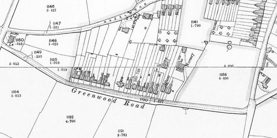
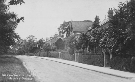
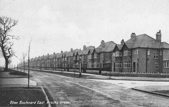
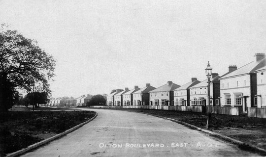
At the time of the Tithe Map, what we know now as the western part of Olton Boulevard East from Shaftmoor Lane to Shirley Road had one house at the Fox Hollies Road end (here a house and shop, later Clifton House). The first houses on the road appeared in the late 1870s. This stretch was then known as Marsh Lane. By 1888 it had been renamed as Greenwood Road. That name remained until 1927, after which the eastern stretch beyond Shirley Road was constructed as a bypass for the centre of Acocks Green and the whole road became Olton Boulevard East. While the part of the road between Shaftmoor Lane and Shirley Road was made into a dual carriageway, the rest remained two-way traffic until the northern side was reduced to a service road as part of the Birmingham Cycle Revolution around 2018. Two-way cycling is possible on this side, but both ends have been barred to cars. Since the Warwick Road up to the Green from the east has been made mostly 20mph, those drivers who prefer 30mph have been able to choose Olton Boulevard East and Fox Hollies Road as an alternative to proceeding in a stately manner through the Warwick Road shopping area.

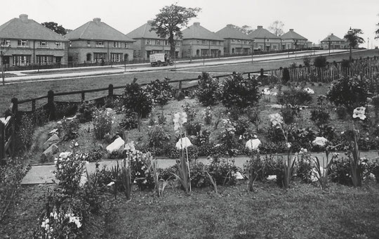
Initially the houses were named, although the names sometimes changed. Around 1924, the houses were numbered. From 1930 onwards, a large number of council houses were built on both sides of the road, and a small number of private ones too.
As the oldest houses are on the evens side, we will start there. The Fox Hollies pub opened in 1928 on the site of a cottage for the kennelmaster of Fox Hollies Hall. It was replaced by Lidl in 1999. There is multi-coloured public art on the Shaftmoor Lane corner, and the Fox and Hollies plaque by Bloye from the pub is in the side wall of the supermarket. Across Fox Hollies Road, Clifton House, former home of the Moody family, was replaced by council flats by late 1964.
Number 28 dates from c. 1932, and numbers 32-50 from c. 1927. Number 44 was a doctor’s surgery during the Second World War. These are in the same style as a row on Hazelwood Road, and were built by Philip Perks, who lived on that road at number 74. The first of the Victorian houses, number 52 (Walnut Cottage, or the Walnuts), appears in an 1880 directory, as does number 54 (The Roseries). Number 54 is wider than number 52, and was divided c. 1892, producing number 56 (The Roseries as well). Numbers 58 and 60 (both The Hawthorns) are also in the 1880 directory. Number 62 (The Ferns) is listed the 1891 census, while number 64 (The Birches) is in an 1884 directory. Numbers 66 (Ash Mount) and number 68 (Donisthorpe) are listed in the 1891 census. Number 70 (Linden/Lyndon House) appears in an 1892 directory. Number 72, a larger house (Woodland Cottage) is listed in the 1881 census. There was no number 74. Numbers 76 and 78 (Stoneleigh and Tintern) are semi-detached and appear on the 1891 census. Numbers 80 (Pensnett Lodge) and 82 (Jesmond Dene) are semi-detached and are listed in the 1901 census.
Number 84 (South View) is listed in an 1888 directory. Numbers 86 (The Limes) and 88 (Sunnymede/Sunnyside) are semis, and the Limes is named in the 1881 census. Number 90 (Fair View) is in an 1888 directory. The semis numbers 92 (1 The Orchards) and 94 (2 The Orchards) were built behind the main row and are now part of The Willows, off Hazelwood Road. Numbers 96 (Summerfield) and 98 (The Meadows), also semis, appear in an 1896 directory. Numbers 100 (?Ebenezer Villa/The Ivies) and 102 (?Emmanuel Villa/The Glen) are in an 1880 directory. Numbers 104 (Lebanon Villa), 106 (Sharon Villa) and 108 (Holly Lodge) were built behind the main row, and can still be reached down a footpath. They appear in an 1880 directory. Numbers 110 and 112 (semis with names Glen Helen and Abingdon Villa) are on the 1888 O.S. map. Numbers 114 (The Lightwoods) and 116 (Belvedere) have the date 1893 on the name plaques. The last of the old houses was number 118, Shamrock Cottage, which is shown on the 1888 O.S. map. This and its grounds were the site of a nursery, owned at first by Walter B. Child.
Later cul-de sacs have changed part of this sequence. Today’s number 68 looks like a 1930s replacement. New numbers 72-4 replaced number 72 when Coppice Drive was built c. 1970. Numbers 76-8 were removed and the left hand of a pair, number 80, was also demolished. Holly Drive replaced number 118 and its grounds c. 1970.
Number 122 is on a 1930-1 voters’ list, and numbers 124-32 on the 1931-2 list. Grayland Close is on the 1930-1 voters’ list. Numbers 136-142 are also on the 1930-1 list. Beyond Shirley Road the first houses on the evens side are opposite Dolphin Lane. Numbers 290-296 are on the 1931-2 voters’ list. Numbers 300-334 are on the 1930-1 list. Numbers 340-362 are on the 1932-3 voters’ list.
The odd-numbered side starts with shops at the corner of Shaftmoor Lane. There is a Centro Fox and Holly piece of public art on the pavement, dating from 2003. The block numbers 1-11A date from c. 1933, numbers 15-29A from maybe a year or so earlier. Numbers 19-21 used to be a Natwest bank branch until the early 1990s, hence the name of the present bar/café. It could be said that the shops and former pub round here formed Acocks Green’s third village, a late 1920s and early 1930s hub following the Green and the Edwardian Yardley Road centre.
Most of the houses on this side from Fox Hollies Road were built as council houses. Numbers 33-157 are from c. 1933. Numbers 199-241 are a year older. They are private houses, built by Crabbe, who lived opposite on Victoria Road. There were two types. The westerly four pairs of semis had side garages and a side extension from halfway along the house behind, the middle set of four pairs had no such side extension and the three easterly pairs had the same side extension as the westerly pairs. Part of Hyron Hall was at the back of this easterly three pairs of semis. Numbers 243-345 date from c. 1930. Perhaps surprisingly, there are also numbers 359-361 and 365-369 opposite Lincoln Road North. Numbers 359-361 were a Co-op (Branch 114) in 1939 (it may have opened a couple of years earlier), and in 1955 numbers 365-369 were occupied by a civil engineering company. Later there were builders and manufacturing, and other small enterprises. The Co-op lasted into the 1970s. Around 1980 numbers 359-361 were the New Boundary Club. Later in that decades they were a plumbing retail outlet. This site is, however, best known as Zorba’s Greek restaurant or Colosseum.


The National Library of Scotland website has 25-inch maps up to the 1930s, and 1:1250 and 1:2500 maps up until 1973. There is also an option to compare Edwardian and current maps of various kinds using a slider. For this use the geo-referenced maps option. This is useful for plotting the exact location of changes.