 Acocks Green History Society
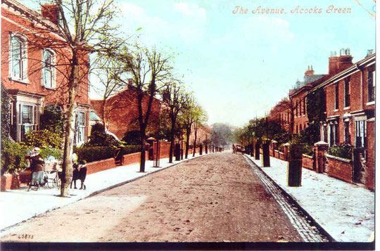
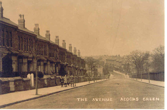
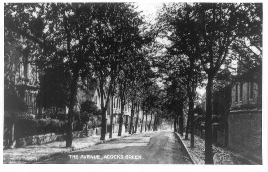
The Avenue
The Avenue, or Avenue Road, or even Great Western Avenue, was an entirely new road created parallel to the railway by the executors of Benjamin Cook Junior. His father was a famous brassfounder. A Benjamin Cook, brassfounder, was listed in Lewis's 1820 directory of Yardley. Benjamin Senior was also a well known public figure and imaginative inventor, and held patents for brass rods, hinges, and gas lighting appliances, just to name a few areas of manufacture. He was listed in directories of 1818, 1818-20 and 1823 at Baskerville House, although he had other business addresses, namely Caroline Street, Brittle Street, and later Whittal Street. Following the presumed loss of Baskerville's former home in the 1790s the area was developed for industry, and it appears that Benjamin Senior took advantage of the ?rebuilt shell for a few years. This may well explain why the house on the Avenue was given the name Baskerville House (house property records, 1872 reference: there is also a name plaque on the front of the house). Benjamin Senior died on 7th February 1849 at the age of 72.
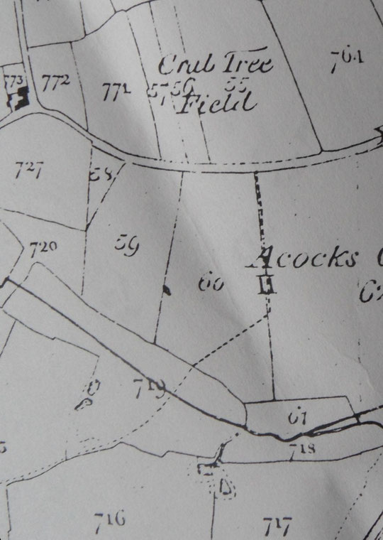
In the 1841 census he or his son owned and did not let out three fields on the Warwick Road and Broad Road, which were built on in the 1850s. His son, aged "30", is also listed in the 1841 census as living at Flint Green. So his son would presumably have been the driving force behind the new housing here. (See also the history of Stone Hall). He was a bedstead manufacturer, working in brass and papier mache, with a factory in Bradford Street and a house at 15, Highgate in 1849 and later on Ladypool Lane, Sparkbrook by the 1850s. In the 1851 census his house is listed not at Flint Green but at Acocks Green Field as Cook's house. However he himself is not living there by then, as we have seen. Benjamin Junior had leased field 60 from November 1838, together with Joseph Cook. So maybe he had a house built on what is now Yardley Road. It is not on Blood's map of 1857, so maybe the railway took it.
By March 1858 he had died, and the executors were Harriet Cook, his widow, and John Horton in a lease of July 1863. Ground rents for The Avenue date from March 1863. She was still living at Ladypool Lane in the 1861 census, described as a landed proprietor aged 56, widow. Perhaps this was the end of an era for the family, and they wished one of the houses to be named after Benjamin Cook Senior's premises at Baskerville House. Harriet died on 9 December 1874 after a long illness.The executors brought about a sale catalogue of May 1875 referred to also on our Botteville Road page. By this time, the estate included much of the core of Acocks Green, including as yet undeveloped land between March Lane (Olton Boulevard East) and Well Lane (Westley Road), Victoria Road, Botteville Road, part of Shirley Road, parts of the Warwick Road and Broad Road, The Avenue, and land at the corner of Yardley and Wynford Roads, plus a field opposite. The estate also included the New Inn and the Great Western Inn. Maybe the area should really have come to be known as Cooks or Hortons Green rather than Acocks Green!
Many thanks to the owners of Baskerville House for property information.
The houses on both sides from Yardley Road down to Roberts Road were built over a relatively small number of years. Joe McKenna describes Benjamin Cook's executors' project in Chapter Four of his book.
Number 1 (Edendale), 3 (Avondale), 5 (Claremont), 7 (Silverdale), 9 (Ashborne), 11 (Fairleigh), 13 (Fairview), 15 (Avonroyd), 17 (Maesgwn), 19 (Bericote), 21 (Avenue House), 23 (Oxford House), 25 and 27 (both Mayfield Villas), 29 and 31 (both Brooklyn Villas), 33 and 35 (Bay Ridge Villas), 37 and 39 (Greenwood Villas), and 41 and 43 (Rose Villas) make up one side by 1899.
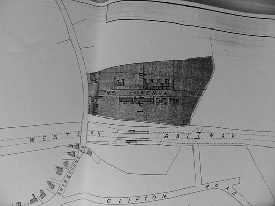
A directory of 1868 lists 6 houses: only one is named: Normanton House, number 12. From the style, perhaps the houses 4-10 were others.
The 1871 census reveals that 9 houses were unoccupied: not a great success story! The Cook estate sale catalogue of 8th May 1875 (Birmingham Libraries 1379), under Lot 19 refers to twenty-one residences: an extract from the map is below. Numbers 1-19, and 2-30, possibly excepting 8, 18 and 24 and 30, appear to be shown. A directory of 1876 shows all 21 as occupied.
In 1881 10 were unoccupied and 25 occupied. One house may have been missed off the list. The 10 new houses are 25-43. The 1888 map shows number 23 was not yet built. So the eventual total comes to 37 houses. Numbers 21 to 27 appear to form one plot, which includes two double-fronted houses (21 and 23). Numbers 29 to 35 are another plot, and the third plot contains numbers 37 to 43. The different styles of the groups of houses suggest separate architects/builders for each group.
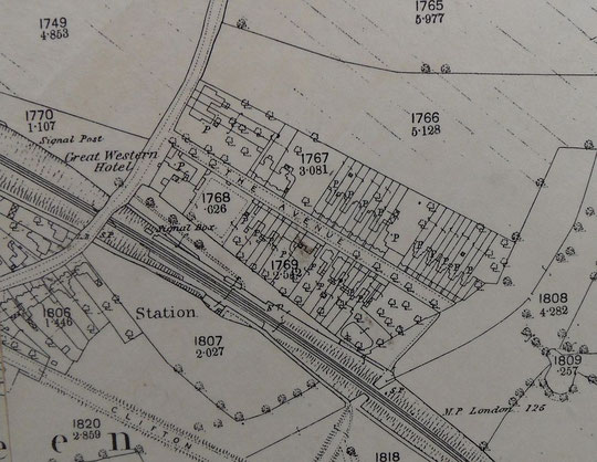
By 1904 houses are shown on the O.S. map from 82 to 126, 128 to 152, 218 to 228, 230 to 252, and 268 to 300. Clearly building was on-going, because 154 to 216, and 254 to 266 are listed in the 1912-3 voters lists. Also by 1912 numbers 241 to 275 had been built. Numbers 2 to 4 Roberts Road and number 54 were also built by then (6 to 20 Roberts Road are on the 1904 map). Numbers 147 to 157 and 171 to 209 are on the 1920 voters lists. By 1930 number three has been subdivided into three households. Numbers 3A and 3B are present by 1930. The council housing numbers 62 to 80, 61 to 87, 99 to 109, 161 to 167, 213 to 223 and 229 to 231 date from 1931.
Numbers 22-30 have been replaced. Numbers 22 and 24 look 1960s in style, and 26 to 40 date from 1979. Tanyards was occupied by four houses by 1979. Land behind the Great Western now has sheltered housing (Great Western Court, c. 2010). Number 3 has been extended southwards and is a dementia care facility. Number 1A is c. 2009.
The Avenue has one of the ways into Westley Vale Millennium Green, a very welcome and pleasant area hidden behind suburban roads.
The National Library of Scotland website has 25-inch maps up to the 1930s, and 1:1250 and 1:2500 maps up until 1973. There is also an option to compare Edwardian and current maps of various kinds using a slider. For this use the geo-referenced maps option. This is useful for plotting the exact location of changes.