 Acocks Green History Society
Transport and housing changes from 1900 until now
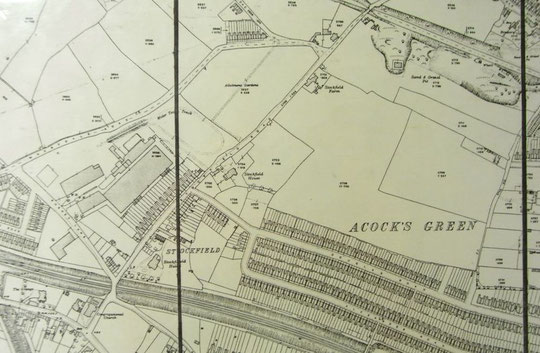
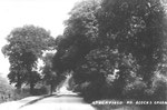
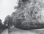
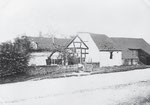
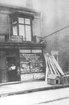
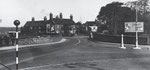
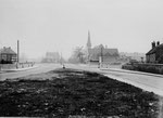
In the 1901 Census a new row of houses appeared on the census. These were on the west side of Stockfield Road opposite Rushey Terrace, and all had names like Grasmere, Holly Bank, and Woodstock, although Kelly’s directory soon stopped using them. By 1903 Stockfield Farm was occupied by Richard Morris. Shops began to appear towards the Yardley Road end, and by 1912 Stockfield Hall was occupied by William Frazer, Mrs Holloway was still at Stockfield House, and Thomas Rowe was at Stockfield Farm. By the 1916 edition of the Ordance Survey 25 inch map, Pinfold Green was lined with buildings on Yardley Road, Stockfield Road, and Mansfield Road. This process had started right at the turn of the century. In the 1921 directory Stockfield Hall has declined to a boarding house run by Mrs. Annie L. Chambers, while Stockfield House now has William T. Rabone as the householder. The Rabone family have a splendid family grave in St Mary’s churchyard.
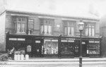
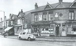
Industry began to appear on both sides of the road. By 1916 a large factory was behind the new terraces, with a motor test track alongside and Douglas Road had joined the extension of Alexander Road to Stockfield Road that was already on the 1904 O.S. map. Business names alongside the west side include Dowding and Plummer, the Stockfield Manufacturing Company, and the Central Radiator Company. However, rather strangely, the city built a short row of system-built houses of the Parkinson type on the west side as part of a 1920s 500-dwelling estate called the Stockfield Estate, which was, apart from these houses, between Stockfield and Yardley Roads north of the early twentieth century terrace roads. The east side of the road acquired Smith and Ansell by Arden Road around 1925. They were electric light fitting manufacturers.
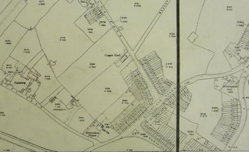
It was at this time that the city turned its attention into widening Stockfield Road into a dual carriageway as part of ambitious city-wide plans to prepare the city for the motor transport future. This had implications for the canal and railway bridges, of which more below. As a result, both Stockfield House and Stockfield Farm were demolished. It was thought that Stockfield Hall would have to go to, but in the end that remained and became the home of the Royal Army Medical Corps 143rd (South Midland) Field Ambulance in 1931. The city had compulsorily purchased it in 1924 with a view to demolition, but accepted an offer from the War Office in 1929. By 1936 Westwood Rim and Patents Ltd, motor car accessories manufacturers, and Foulkes and Bailey Ltd, motor transport contractors were alongside Smith and Ansell.
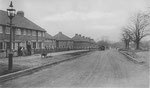
Privately built semis appeared between Douglas and Mansfield Roads at the same time, with those near and on Kilmorie Road built by Dare's. The north corner of Wharfdale Road also saw a short row of semis built. By 1939 it appears that Rushey Terrace and Stockfield Villas had gone. The Royal Army Medical Corps 48th (South Midland) Medical Services and 145th Field Ambulance were at Stockfield Hall as well as 143rd. Social life saw an improvement with the opening of the Speedwell Tavern on 18th January 1929. It was designed by Bateman and Bateman, and stood between the canal and the corner of Amington Road, formerly Tanyard Lane.
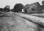
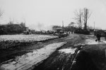
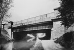
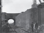
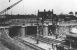
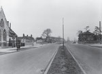
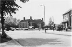
Above we mentioned the widening of Stockfield Road into a dual carriageway for most of its length. There are two bridges on the road, both of which needed to be widened. The first one to be done was the canal bridge. Work started in the summer of 1925, and continued into 1926. A photograph of the completed bridge appeared in the Birmingham Post on 15th December 1926. "Three years ago this land was being farmed. Over 200 concrete houses have been completed, the road cut, and a new bridge constructed. The duplicate one-way carriageways are each 25 feet wide, and the width between the buildings is 160 feet. The total width of the bridge is 64 feet, the carriageway being 36 feet wide." Canal traffic declined despite work to improve what had become the Grand Union Canal. After wartime revival, commercial traffic dwindled to nothing. Pleasure cruising was tried from Stockfield after the War, and during the Yardley Festival of 1972: nowadays only private vessels disturb the canal's solitude. The railway bridge near Rushey Lane was replaced between 1939 and 1940. That work continued into the War is not unique.
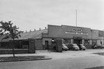
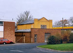
By 1950 Stockfield Hall hosted the R.A.M.C. 9th (Northern) Field Ambulance (T.A.), the R.A.M.C 22nd Field Dressing Station (T.A.), and the Royal Warwickshire Regiment 5th Cadet Battalion. The 148th (South Midland) were there instead by 1963. In 1956 the Congregationalist church closed and was sold to the Bible Pattern Church Fellowship: it became known as the Warwick Road City Temple. The church was demolished in 1973. In 1981 Colliers moved from the Swan and eventually took over the church site, adding to their 1973 purchase of the old Gethin Rover dealership at the Grange on the Warwick Road. By 1968 numbers 25-39 Stockfield Road had been demolished and replaced by a service station, initially supplying Mobil products.
Frank Taylor Lockwood sketched and painted scenes of Stockfield Road in the 1950s, which are accessible on the City Museum and Art Gallery's site. These are the links:
http://www.bmagic.org.uk/objects/1995V412
http://www.bmagic.org.uk/objects/1995V409
http://www.bmagic.org.uk/objects/1995V406
http://www.bmagic.org.uk/objects/1995V401
By the 1980s it had become apparent that the various types of system-built housing the city had used to build some of its estates were in serious difficulty. The Parkinson houses were suffering from structural defects in the pre-cast concrete sections. The Housing Defects Act of 1984 provided for repairs up to £14,000, but it was found that these houses could not be given a satisfactory life span for this amount. Accordingly the city decided to redevelop the estate, which was also notorious for social problems. The city came up with a partnership plan to maximise social rented housing, bring in private finance, and enable continued city involvement in the development and running of the estate. The Halifax Building Society and the Bromford Carinthia Housing Association became partners and the Stockfield Community Asociation was established. This is a non-profit making charitable company, which, however, had a subsidiary trading arm. The estate was redesigned with more parking, better security, traffic calming, courtyards and cul-de-sacs instead of through roads, and an improved park. The area over the other side of Stockfield Road, which had included a small part of the original estate, was redesignated as industrial. The housing has a mixture of tenure types and house types. Construction was in phases, beginning in 1991. Local residents were heavily involved in all decisions and management. To read about this, go to their website, navigate to the Downloads page and look for The Stockfield Story.


The rest of the nineteenth century
Transport and housing changes from the twentieth century until now