 Acocks Green History Society
History of the Coventry Road, Hay Mills
This part of the Coventry Road is special, if that is the right word, because almost all the buildings on one side of it were removed for road widening. On the north side, the majority of the original shops are still there, if well past their heyday. However, there is now an opportunity to recreate most of the south side from about 1900 to the mid-1980s. This is thanks in part to Edwardian and later postcards, and also to the work of the Hay Mills Project, a Manpower Services Commission project created to record the road before the rest of half of it was bulldozed. One of the leading lights of that project was the photographer Brian Matthews. However, not all his work made its way into the project, which only lasted a short time, while he continued with photography as a hobby after retiring from work. Brian died recently, and his sister has agreed for his work to be featured on this website, and at South Yardley library. Our thanks go to Linda and Tony Chew, and also to Keith Clenton for some of the scans.
Numbering started around 1899, but was initially using even numbers, starting from the River Cole with number 2 for the south side. Even by 1912, though, this was not applied after Ada Road. Around 1922 the numbers changed from even to odd, and, what's more, started with number 1001 on this side of the road, reflecting the Coventry Road as one long road in the city ten years after the absorption of Yardley into Birmingham.
The mid-nineteenth century and early urbanisation
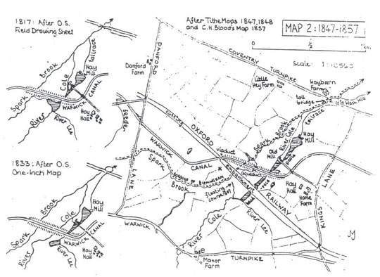
The mid-nineteenth century Tithe Map reveals something interesting about the Parish Boundary and also the industrial use of water.
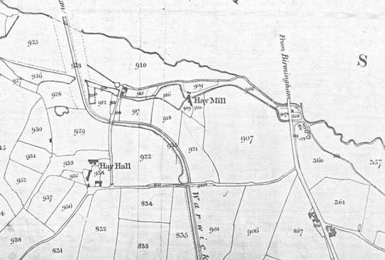
North is on the right in this map. The boundary is the Spark Brook, but here it flows into the Cole below Hay Mill, not before the canal embankment as now. The reason is that waterpower was used for the mill, from both the Cole and the Lee. The John Morris Jones map below shows this in detail. The tailrace from the mill does not enter the Cole until north of the Coventry Road, so this channel east of the river prevented building at that point on the road. At some point after waterpower was abandoned, the floating course was lengthened into the Spark Brook, and this took Cole water into the boundary stream higher up, which led to the stretch downstream being redefined as the Cole.
As late as the 1880s the O.S. map shows the tailrace running north across the road from the workmen's cottages by St. Cyprian's church and then bending to the right and left past the Hay Mills Tavern to then pass under the Coventry Road. For this layout see the NLS Maps website at:
https://maps.nls.uk/view/115633365 and
https://maps.nls.uk/view/115633377
The race was later filled in, but a gap remained on the road frontage on the south side, only part of which was filled by the 1920s Memorial Hall. On the north side buildings stood by 1905 from the Plough and Harrow eastwards, with a gap next to what became number 1008: possibly where the tailrace had been and the ground was less firm.
Chronicle of the partial destruction of Hay Mills
At one time it was said that if you couldn't find something in the Hay Mills shops it wasn't worth buying. The shopping centre had developed to service the local population both sides of the Coventry Road, brought to the area by industry. However, in early 1962 discussions began about bypassing the Coventry Road in Small Heath and extended to include the Hay Mills stretch. It was decided it would be too costly to run a bypass through the industrial area to the south of the Coventry Road, and initial plans involved removing the shops both sides. In April it was revealed that the south side had been scheduled for demolition for many years, but not the north side. However in December 1962 a "happy compromise" was reached which would mean only the south side shops and houses would be demolished. More than fifty traders had petitioned the Council, saying the plan would almost erase the Hay Mills shopping centre. Part of the plan was an elevated section of road from Gladys Road westwards:
"a quarter-mile elevated stretch which will start to rise at Gladys Road. The express road will be 20ft. above the old Coventry Road near Redhill Road. It will swing away south near the River Cole, and then descend to ground level." "The new (four-lane) road will start to rise on stilts above the line of the present Coventry Road as it leaves the city side of the Swan underpass scheme.... It will have to be elevated to allow through traffic to Small Heath on the present Coventry Road." (Birmingham Daily Post, 1st December 1962)
The City was in essence determined to save the shopping centre at Small Heath, but not the one at Hay Mills.
In 1977 the Expressway was re-named the Small Heath Bypass. The West Midlands County Council and the City Council were pressing government for an early start, including permission and financial support. A year later the government had not come up with these, and the County Council decided to proceed anyway, hoping to use money which had actually been allocated for improvements in inner city areas. The scheme was slimmed down: the original Expressway was planned with six lanes along the whole stretch. As regards Hay Mills to the Swan, this was planned for 1983-4 at a cost of over £3 Million pounds.
In 1980 delays were reported. The County Council was refusing to buy affected homes in advance. It was taking longer to schedule the land and bring in Compulsory Purchase Orders. However the County Council had a new plan for the Hay Mills stage - a flyover, no less. The foundations for this, it was reported, were being built.
In May 1983, Compulsory Purchase Orders were created. By 1984 the cost of the third stage of the Bypass (Hay Mills) had risen by £1.6 Million above the 1983 estimate, then of £5.85 Million. The costs of acquiring the land had risen. £860,000 of this was for rehousing families and the prices for buying the Hay Mills Unionist Club and the old Bulls Head were £350,000 higher. The Bulls Head turned out to be much busier than had been estimated. The City Council was expecting the County Council to pay it for the expense of rehousing forty-three families. Stage Two of the Bypass, up to the Cole, opened in January 1985, and it was now anticipated that Stage Three would be completed by July 1986.
In the Spring of 1985 the E.E.C. came up with £5.5 Million. This was approved because Stage Three would improve access for industry, especially to a proposed high technology park. However, there was a risk that this money would be lost as a result of government delays to the start date. A ceremony took place to mark the start of Stage Three at the end of November 1985, between George and Kings Roads. Stage Three's opening date was now to be in December 1986. Part of it involved the widening of Kings Road as far as Speedwell Road. The opening did indeed take place when planned. Councillor Bill Turner said that the completed Small Heath Bypass would give businesses and people visiting the City "a much prettier drive, compared with other routes to the airport". Quite an extraordinary statement when all consequences are taken into account.
Hay Mills got itself a new retail park, but it also acquired a racetrack. There was a petition almost exactly a year after the six-lane section opened demanding something be done about speeding to prevent death and carnage. In February 1988 it was announced that speed warning lights would be installed to show 40mph was the maximum speed. Apparently these were the first of their kind in the City.
Our history will deal with the two sides of the road separately. We will start with the south side to Forest Road.