 Acocks Green History Society
All around the Ackers, by John Morris Jones
This booklet is reproduced with the permission of John Morris Jones's widow. It was originally published by the Ackers Trust in 1984, and is now very hard to obtain. It is reproduced here with only minor alterations. Although much has changed in terms of industry, it is as a snapshot of the locality around the Ackers that makes this valuable, in addition to the detailed discussion of the watercourses along Yardley's border.
What can be seen from Ackers Hill
From the windswept summit of the artificial mound called "Ackers Hill" a large part of central, east, and south Birmingham can be seen. There is a fascinating variety of topographical features in view, and much to be learnt about each of them. Let us first identify what we can see, with the aid of the toposcope provided, then study everything separately and in detail.
Almost due north the viaduct of the Oxford Railway crosses the Warwick Canal. Beyond are factory buildings, which used to be the B.S.A. Waverley Works and the Singer Car Works, with long Edwardian streets beyond. The Coventry Expressway curves around the factories, alongside the River Cole. The riverside Hay Barn recreation ground is visible past St. Cyprian's Church, the factories of Hay Mills, and Coventry Road. To the north-east, Yardley Church's spire and the distant cooling towers of Hams Hall power station are seen over 1920s municipal estates. On Red Hill to the east, the tall blocks are the Swan Office and Tivoli centres at "South Yardley". Canal and rail embankments cross the valley, and Spark Brook is joined by the Cole below the mound. To the south-east, multiple lines fan out below Tyseley Hill, flanked by Hay Hall industrial estate, the junction station, the Railway Museum and British Rail's Area Maintenance Depot.
Due south are a playing-field, the largely Edwardian suburb of Greet, and a fairly new industrial estate. Looking down the future ski-slope, we see the long sheds of the former rifle testing range. The motorcycle track and sports field lie westward: between the canal and the railway to the northwest are the remnants of the B.S.A. factory, the Spicer Cowan complex and a new industrial park that is being built on part of the cleared site. The Expressway points towards the city centre's towers. Small Heath Park and its pool appear to northward amid late Victorian villas.
The natural landscape (map one)
The story of "the Ackers" and its environs is best told chronologically, beginning with the appearance of the landscape before it was settled and altered so drastically by man.
The marshy valley floors of the Cole and the Spark and their confluence with lesser streams still carry the vegetation appropriate to an often flooded expanse of silt and gravel: the watercourses have experienced many changes, both natural and man-made, and there has been some land-drainage, but the area south of the railway is least altered. North from there, the embankments and industrial dumping upon formerly flat flood-meadows have created artificial relief - the spectacular gorges in which the streams flow are very recent in the district's history.
Natural cover was of three kinds. In the water meadows, grass, reeds and weeds alternated with clumps of willow, as now. On the gentle clay slopes of the valley sides, dense oak forest grew, with thickets of impenetrable bush and bramble beneath giant trees. The sandy and gravelly plateau level above bore variable wood, thinning out from oak, elm and ash, with underbrush, to hazel, birch, gorse and broom on the stoniest patches. 'Small Heath', originally at the junction of the Coventry Road and Green Lane, was one of these. Hay Hall was established in the middle of a circular deposit of gravelly drift, which provided a clearing in thick wood. The 'hay' was an enclosure, fenced for agriculture against wild creatures. Heybarnes (Hay Barn) was another. 'Golden Hillock' was covered in gorse and broom after clearance of the great timber in Tudor times.
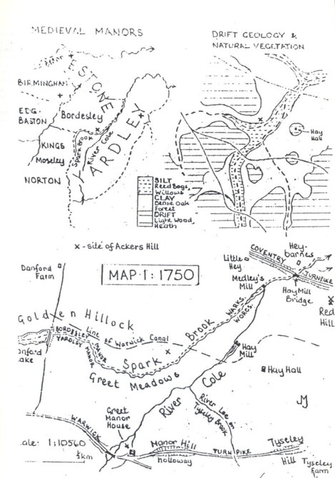
Watercourses (maps one to six)
The River Cole's name can mean either 'hazel' or 'charcoal'. The latter is more appropriate because the oak woods through which it flowed provided charcoal for Birmingham's forges over many centuries, and the fitful stream may sometimes have been usable for transport on rafts or punt-like boats. The Cole is about 40km long, rising south of Kings Norton, falling fairly quickly in its direct upper and middle courses, joining the River Blythe near Coleshill after much slow meandering. Though never a major watercourse - its alternate Georgian names hereabout were Greet Brook, Hay Mill Brook - it used to be much more impressive than today's customary trickle. Bordering forests retained rainwater, releasing it gradually to countless small tributaries, so that the usual level was higher. Once cleared of timber, the impervious claylands shed water rapidly, creating sudden floods. Field drainage accentuated this fast run-off. Lacking major feeders, the middle Cole falls as quickly as it rises, but its floods have taken lives and destroyed bridges throughout recorded history. When swollen, the Cole, fed by Tyseley Brook, was joined by Spark Brook (described as a 'torrent' in 1511), and the whole confluence plain would be briefly inundated, creating a lake 300m across.
The Spark Brook, 3.3km long and named after a local family, rises at Showell Green. Since 1896 it has been culverted beneath Stoney Lane and the Barber Estate off Walford Road. It appears above ground beside the former B.S.A. sports field. Tyseley Brook, alias 'River Lee', rises near Hall Green Church and flows north-northeast to join the Cole upstream of the Spark. It is partly culverted: from the Warwick Road it runs in an artificial channel, having been diverted to permit the extension of railway sidings across its valley.
Other alterations to stream courses around "the Ackers" are not fully authenticated, due to the conflicting evidence of early maps. Beighton!s 'Mapp' surveyed in 1722 (scale 1:63360) is the first to show the channels in detail, but is unreliable. It transposes Hay Barnes and Hay Hall, and places Medley's Mill on the Yardley bank of the Cole. Two arms of the river have Hay Mill at their confluence, and two arms join Spark Brook below the mill.
Field Drawing Sheets (1:126720) for the Ordnance Survey, 1817, show the Cole, the Spark and the Lee joining in a pool south of the canal embankment, and a single channel flowing from there. At Hay Mill Cottage, a headrace continues to a triangular millpool, and the main flow curves round it; the two arms rejoin 400m south of the Coventry Road.
The First Edition of the O.S. One-Inch Map (1:63360) c.1822 is more accurate in some respects and may be more reliable hereabout. It shows three channels under the canal - Spark, Cole and Lee; the last feeds a rectangular pond above the embankment and serves as the headrace to Hay Mill. No confluence of channels is shown above the mill, and the tailrace continues to beyond the Coventry Road. Doubtless in flood the three courses combined. The reason for the long tailrace is that after turning the breast-shot wheels, the water was in a well below river level, and could be returned to it only by a channel of lesser gradient: by trial and error this had been found to require a leat of 400m, with a culvert under the turnpike.
The 1841 Tithe Map of Yardley (1:5280) shows two channels only. The Spark is almost joined by the Cole and a straight branch from the latter is fed by the Lee, having three pools upon it and a floodrace at Mill Cottage running beside the lowest pool to join the Spark below the mill. This finely-drawn map is the first to achieve modern standards of accuracy. On it we see that the Cole flow is normally down the headrace: the channel leading towards the Spark is a 'floating course', a dead-end cut which would overflow into the brook only in flood. Downstream of the canal, a channel leads to the floodrace from the embankment foot, and this may indicate a culvert used to drain the meadow on the south side of the bank.
Blood's splendid map of 1857 shows the Oxford Railway viaduct over the canal and the embankment across the confluence meadows south of it, cutting in two the uppermost of the three pools. We see also that for reasons unknown and not readily discoverable, the combined Spark/Cole channel (the floating course having been extended) has been diverted from the old Spark course to flow for 120m between the two banks before going under the aqueduct from which the Park takes its colloquial name. There is no doubt about this diversion: on all subsequent maps the ancient boundary is drawn following the old brook course directly across the canal. No trace of the original 1790s culvert on this line can now be found.
Floods were a greater problem when two barriers impeded flow down the valley, and by 1887 (O.S. Map Second Edition One-Inch) and First Edition Six-Inch (1:10560) a relieving course had been made. A weir just below the junction of the Cole and the Lee fed water to this: the brick-walled channel between the two banks joins the Cole/Spark at the aqueduct: this was given two arches, one of which is normally dry.
Widening of the rail embankment to support extra lines after 1907 necessitated extension of the three culverts beneath it: as by then water was no longer used for power at Hay Mill, a low arch was made for the headrace, sufficient only to prevent the channels from drying up.
Severn-Trent Water Authority has acquired control of the Cole system from the City and Trent Water Board. Amenity is desirable, but flood control is always the chief concern. A double concrete weir has been built below the confluence of the Cole and the Lee: the higher upper dam maintains the river level for the benefit of wildlife and citizens, and the lower forms an intermediate basin which prevents erosion of the soft clay bed by water which would otherwise fall some 1.5m. The overflow channel, with a newish concrete portal in the rail bank, has no approach arm at the weir: in exceptional floods, water can drain into a ditch parallel to the bank and so into the channel, but usually the only flow therein is what has backed up from the main Cole/Spark course. Downstream of the Waste Disposal Unit, a balancing lake has been created: excess water can be diverted into this and released when the river is low.
Early settlement and boundaries (map one)
Facing south, upstream on the Cole, you are looking towards Berry Mound, 8km away in Solihull Lodge. It is a permanent earthwork camp of 6.6ha and of Iron Age date, protected by ditches and banks and formerly by high palisades, and was probably occupied when the Roman legions conquered the Midlands in 48 A.D. Possibly it was the tribal centre for this part of Arden. Our name for it, meaning 'fortress hillock', was given by Hwiccan (West Saxon) immigrants some six centuries later. They moved north from the Avon, establishing scattered farms and hamlets in woodland clearings, giving them names which have come down to us as (Kings) Norton, Moseley, Yardley and Tyseley. The -ton ending means 'farm' and -ley means 'clearing settlement'. At the same time that the Hwiccans were moving north, in small kinship groups, Anglian colonists were moving south up the Tame and the Rea. They met at the Cole and the Spark.
The tiny Spark has had remarkable significance as a boundary line. On this, the north side, descendants of the first settlers became subject to the Anglian kings of Mercia, and those to the south and east of the Hwiccan kingdom, Wigornia, whose capital was Worcester. From this initial separation came all the rest during thirteen centuries. Here we stand in Mercia, the Diocese of Lichfield, Coleshill (later Hemlingford) Hundred of Warwickshire, the Domesday manor of Estone (Aston) and the parish of SS. Peter and Paul, the early medieval manor of Bordesley, the Civil Parish of Aston from the later 16th century, Bordesley Ward of the Borough of Birmingham from 1838, Sparkbrook Ward of the City of Birmingham from 1889, and the B12 postal district.
When we cross the Spark, we are historically in the See of Worcester, Pershore (later Halfshire) Hundred of Worcestershire, the Domesday manor of Gerlei (Yardley), the parish of St Edburgha, the medieval manor of Greet, the Greet Quarter of the Civil Parish of Yardley, Solihull Poor Law Union, Sparkhill Ward of Yardley Rural District from 1894, and of the City of Birmingham from 1912, and B11.
What can be seen from Ackers Hill
The natural landscape
Watercourses
Early settlement and boundaries
Ackers two
The Manors
The Warwick canal
Railways
Industry
Ackers three
Urbanisation
Parks and open spaces
Churches and schools
The Ackers leisure park
Itinerary
Maps