 Acocks Green History Society
Urbanisation (maps three to six)
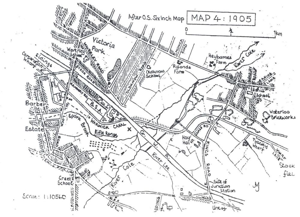
Until a century ago the environs of "the Ackers" were still wholly rural. Hay Hall and its Home Farm were the only buildings nearby apart from the mill and cottage. Then a few terraces of 'artisan dwellings' were put up on short streets at West Greet off the Warwick Road, and off the Coventry Road east of Kings Road. The Sydenham Tavern, with qardens, bowling green, dancing platform and pool was built by Small Heath Station to cater for townees as well as the inhabitants of the spreading suburbs. The Cole valley was popular for summer evening and weekend walks, reachable on steam trams as far as Charles Road, and the over-large pubs of the 1890s flourished thanks to ramblers and cyclists. By 1900 villa rows extended along the Coventry Road's north side nearly to Heybarnes Farm, and three long straight streets had been largely built up with continuous tunnelback terraces east of Victoria Park. (Since the Victoria Laundry and telephone exchange disappeared, there is no reminder of the Park's proper name: 'Small Heath’ is the name applied incorrectly to nearly two square kilometres of suburbs between the Oxford and Gloucester Railways, Green Lane and the Cole.) The B.S.A. had built 'groves' of small houses for its key workers off Armoury Road. Hay Mills was a growing detached village, extending across and up the Coventry Road. By the start of World War One, East Greet and Tyseley Hill were terraced. Between 1890 and 1915, Charles Hougham developed the Wingfield-Digby estate west of Heybarnes, the long streets being named after members of the owning family.
During the 1920s, municipal estates of pairs or short rows of houses were built across local farms - Manor and Tyseley Farms, Heybarnes, Deakins, Hobmoor and Fast Pits Farms. A road was made down both sides of the Cole - starting with Heybarnes Road on the west side, and Berkeley Road East/Millhouse Road on the east side. Apart from rebuildings after bombing, there has been little new construction since World War Two, except replacement of the oldest parts of West Greet.
Parks and open spaces (map six)
In 1876, Louisa Ann Ryland, who had already given Cannon Hill Park to the people of Birmingham, gave 17.6ha of Little Hey farmland for a park and later met a third of the cost of laying it out with walks, flower beds, pool and bandstand. After the Queen's visit in 1887, it was re-named Victoria Park, and an open swimming pool was provided. Digby Park, 3.8ha, was given in 1906 and opened five years later: both parks were at the urban edge when presented.
The approach of suburbia, and existing industry at Greet and Hay Mills, threatened the green peace of the Cole valley. Yardley Rural District Council had neither powers nor funds to save the Cole from the Rea's fate, but it expressed the hope that a narrow strip of meadow would be dedicated to the public, through which a made-up path would stretch, 15km from Solihull Lodge to Sheldon. The scheme would depend upon the generosity of landowners. Birmingham absorbed Yardley in 1912 and added the green ribbon to its Town Plans of 1918 and 1924. Charles Hougham and A.H. Foster gave land south of Greet, and although those reaches of riverbank were not opened until 1969, much had been done elsewhere in the 1920s. Hay Barn recreation ground was opened, and the Cole was 'improved': this involved dredging and straightening, which removed the refuges of fish - the last trout being lifted in 1926. [Since the infilling of the Burbury claypit and the creation of the Ackers Park paths, the walk has been completed by a footbridge which links Manor Farm recreation ground to the Park].
Churches and schools
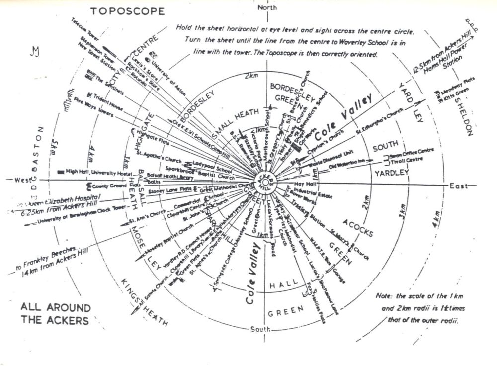
Sixteen churches are readily identifiable from Ackers Hill. The oldest is St. Edburgha's, Yardley Parish Church, whose magnificent tower and spire were built in the 15th century. St Mary's Acocks Green (1866-82) was restored in the 1950s after bomb damage. St.Cyprian's (1873), built by James Horsfall, and St John's Sparkhill (1889-95), are daughter churches. St Gregory's (1902-1916), St Benedict's (1905-10) and St Agatha's Sparkbrook (1901) were initially chapelries within Aston Parish. St Ann's (1874) and St Agnes (1884-1932) in Moseley, and All Saints' Kings Heath (1895) were chapelries of Kings Norton. The Baptist churches on the Stratford Road, in Sparkbrook and on Oxford Road, Moseley, were built in 1878-9 and 1888. The Methodist church on the Warwick Road, Tyseley, was opened in 1914, that in Cambridge Road, Kings Heath, in 1897, and that on the Warwick Road, Greet, replaced a bombed church in about 1950. The Catholic churches of English Martyrs, Sparkhill, and Holy Family, Small Heath, were opened in 1923 and 1928.
Not all the schools in the district whose staffs and pupils are interested in "the Ackers" can be seen from the hill. Those visible include Moseley Grammar School (built as Spring Hill College in 1853) and now part of Moseley Comprehensive, the Horsfall School beside St Cyprian's (1863 - closed), King Edward VI Camp Hill Schools (1883-93), Waverley (1892), Oldknow, (1905), Yardley Secondary 1910-53 (now Lower School of Yardleys Comprehensive), St Benedict's 1913, Commercial School (1931) and now Sparkhill Centre, and Holy Family (1950). The tower of Marlborough School (1898) is just to be seen when the Digby Estate's trees are bare.
Schools within a 2km radius of the hill are as follows: their dates like those of churches are a true indication of the period of their district's urbanisation, except for those built or rebuilt since World War Two. Acocks Green 1909, Alston 1926, Anderton Park 1896, Archbishop Ilsley 1957, Arden (Sparkhill) 1970, Bierton 1928, Billesley 1925, Bordesley Green 1902, Clifton 1878, Christ Church 1871/1958, Conway 1900, Cottesbrooke 1933/1968, English Martyrs 1911 rebuilt 1950, Gilbertstone 1950, Golden Hillock 1910, Greet 1892, Hall Green 1893/1925-9, Hartfield (Ninestiles) 1929, Highgate 1967, Holy Family 1904/1950, Holy Souls 1907/1968, Hobmoor 1933, King David (from St Luke's Road) 1965, King Edward VI Camp Hill Schools, Kings Heath, 1956, Ladypool 1883-98, Lakey Lane 1935, Montgomery 1879, Moseley C. of E. 1828/1969, Moseley Secondary 1955, Oaklands 1929, Park Hill 1954, Percy Shurmer 1967, Pitmaston 1931, Oueensbridge 1952, Redhill 1892, Regents Park 1973, St Bernard's 1967, St John's, Sparkhill, 1856/1884/1970, St Martin's 1969, St Monica's 1970, St Michael's Jenkins Street 1873-1931, St Peter's, Highgate, 1873/1933, Severne 1930, Small Heath 1977, Somerville 1894, Springfield 1900, Starbank 1927, Stechford 1894, Tilton 1891, Tindal 1880, Waverley, Hobmoor Road, 1925, Wheelers Lane 1939, Wyndcliffe 1878/1973, Yardley, Church Road, 1909, Yardleys, Forman's Road, 1907, Yarnfield 1928, Yorkmead 1937.
Other buildings identifiable from the Hill include Yardley Rural District Council House 1902 (directly behind the English Martyr's Church Tower), Moseley Library and Baths 1895/1907, the University clock tower 1910, the Queen Elizabeth Hospital 1938, the Rotunda 1965, Aston University from the 1950s onwards and the Post and Mail Building 1965. The many steel and concrete towers in view have been erected during the last three decades.
The Ackers leisure park
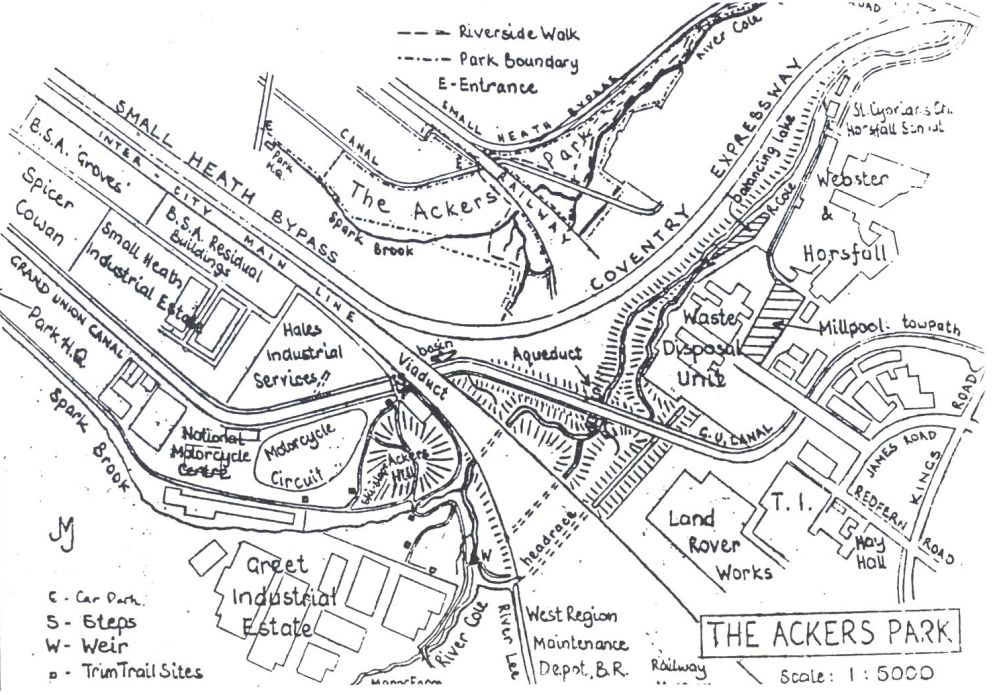
The award-winning studies and reclamation work of 0ldknow School drew added attention to this piece of wasteland. West Midlands County Council produced a scheme in 1977 for its reclamation in association with the making of the Small Heath Bypass. Local councillors and community groups saw many educational and amenity possibilities. In 1979, the Ackers Trust was established with prominent Trustees, a Project Manager was appointed, and the Trust became a registered charity in 1981. Its objectives were, and are, reclamation, development and conservation, its purpose to create a complex of amenities to benefit the whole community: education, recreation and participation are the watchwords. The 19ha of land designated as The Ackers Leisure Park was owned by the City Council, the Waterways Board, and British Rail. The County Council has spent half a million pounds on development so far, and as much again is required to complete present plans. 30,000m³ of bricks, rubble and soil have been moved and smoothed to create the Ackers Hill on an existing dump, the ski-slope and the motor-cycle circuit. Grass seeding and the making of car-park, paths, steps and bridges have been followed by the planting of 30,000 trees, some of them by local schools. The circuit, Trim Trail and canal basin are in use: the former B.S.A. Club building of 1938 and later, is being altered for use as a centre for the Ackers Scheme. Future activities will include boating, canoeing, camping, climbing, picnicking and riding. [The Riverside Walk has been completed from the Warwick to the Coventry Road]. There may be a direct link between the Park and the Railway Museum. A dozen species of bird and a hundred-plus varieties of meadow and bank plant already make the Park a naturalist's delight. A pool to be made at the confluence and stocked with fish will attract aquatic birds. As plantations grow, insects and small mammals will increasingly share "the Ackers" with the human community.
Itinerary
(Note: it may not be possible, or safe, to go where Mr. Jones went. This text is included for information, not to suggest taking the routes indicated. Anyone who does so acts at their own risk. Caution, care and getting permission are advised, should anyone take it upon themselves to follow this itinerary).
|
A tour of the Ackers Leisure Park should begin on the artificial mound near the canal/rail crossing. It is reached from Golden Hillock Road, either by way of Armoury Road, or through the sports ground. The former is flanked by, on the right, the Spicer Cowan complex and Small Heath Industrial Park built on the site of the 1915 buildings of the Birmingham Small Arms Company Works: and on the left by the short groves of terrace houses built by the firm for key workers at the turn of the century, and some industrial buildings of like date - one of which still bears the legend "B.S.A. Guns". Turning left across the site of the original 1863 building, and skirting Hales Industrial Services, the drive runs parallel to the Oxford Railway of 1852. B.S.A. employees used to have a footway across the rails to the Waverley Works. The Warwick Canal of 1793 is crossed by a new bridge.
The mound is constructed on a site long used for industrial waste dumping. Its present dimensions were attained by piling rubble from the Small Heath clearances and covering it with soil and turf.
From the summit, at about 125m 0.D., there is a splendid view of the neighbouring districts. The toposcope indicates what features can be seen, and the previous pages tell more of the geographical and historical story. Skylines are at varying distances: Moseley and Bordesley Green ridges hide the districts beyond, but the cooling towers of Hams Hall power station can be seen 12.5km to the north-east, and the Lickey Hills to the south-west, 14km distant.
Descending from the mound by way of the ski-slope path, we have the National Motorcycle Circuit and the long sheds of the former rifle-range to our right. Spark Brook, the ancient manor and shire boundary, is crossed by a timber bridge. The brook is usually a mere trickle because for most of its course it is underground, and the rills which used to feed it are dried up or diverted into drains. Ahead are the post-World War Two factories of Greet Industrial Estate: they have replaced a number of small well-dispersed sheds where Wilders' Fireworks used to be made. [Now that a footbridge has been built across the Cole from Manor Farm recreation ground, the riverside walk from Solihull Lodge to Sheldon is nearer completion]. The Ackers Park paths link the Warwick and Coventry Roads.
Turning left, we follow the path to a double weir on the River Cole, crossing two of the many brooks which used to flow across the flood-meadows. The weir is a concrete wall which keeps up the river level. An earlier one ensured that most of the water went down the headrace of Hay Mills: that is the channel which leads away northward and is the original course of the Cole. The weir is set in clay, which is easily softened and worn away by water. To reduce erosion of the foundations by floods pouring down the face, a triangular basin has been built in front of the Weir to break the fall. Usually the water level is so low that we can walk across the top of the weir and follow the river northward. The River Lee (undeserving of its title) comes in from the opposite bank: it has been diverted round the railway sidings. At the foot of the railway bank is the barred entrance of a low tunnel which formerly took water to the millponds. 40m north is the concrete arch of a silted runnel, made to carry away floodwater: only when the river is exceptionally high is there a flow down it. The high third arch, 60m west, is the entrance of the culvert for the Spark, joined by the Cole overflow. All three tunnels had to be extended in 1906-7, when the railway embankment was widened to accommodate extra lines going to sidings and engine sheds below Tyseley Hill.
We must retrace our steps across the weir, unless the Cole is low enough for fording. Gravel in the bed, which gave its name to the manor of Greet, provides firm crossing at low water. Where there is only black silt, crossing even the narrow Spark is difficult. Skirting the mound, we climb its eastern slope, looking down at the brook/river arch and observing the barriers erected to stop children falling from it and trespassing on the railway. At the car park's far end we take a path beside the canal and under the viaduct. The nearer part of the tunnel was added in 1907 to the farther one of 1852. Emerging from it, we see that the steel viaduct is all of the same period, having been rebuilt during the extensions. Stumps in the canalside concrete are of railings removed in World War Two, when ferrous metal was needed for munitions. A park path has been made along this side of the canal, but the towpath, where for thirteen decades horses plodded along drawing narrow boats, is on the other bank.
Leaving the canal bank and following one of many tracks made by exploring children, we look down on the north end of the main culvert. Spark/Cole water turns sharply to flow between the two high banks. Why this diversion is made is hard to understand: the Spark used to go straight under the canal, and the old boundary between Bordesley in Warwickshire, wherein we stand, and Yardley in Worcestershire, still followed that line until Yardley became part of Birmingham in 1912. There is no trace of the 1790s culvert, but the water still tries to go directly. It is wearing away the canal bank on the outside of the bend, and a costly wall must be built to prevent further erosion. Back by the canal, we walk along to and cross the brick aqueduct which gives the Park its name. With care we can descend to the junction of the two channels. Spark/Cole comes east in the cleft between the embankments, and is joined by the brick overflow course. This is silted and overgrown: in flood water backs up above the aqueduct arches and briefly fills it.
Those who enjoy a brambly scramble may climb a mound between the overflow channel and the headrace. This was created by boat-borne domestic refuse dumped between the Wars: it brings the level up to that of the railway, and is a good place for train-spotting. Like the other channels, the headrace lies deep in a wholly artificial gorge: the eastern side was built up for extensions of the Rover Car Works between the Wars. We now have a choice of routes. If the river is low, we can re-cross the aqueduct, descend beside it and go through the western arch beneath the canal - but this should not be attempted unless the culvert is completely dry. The alternative is to re-trace our steps to the car-park, cross the canal, and descend by the steps to the towpath. On the bridge, see to the left a roving bridge against the B.S.A. wall. This takes the towpath over the entrance, now blocked, of a short arm into the Works. There was direct access by water between the Gun Proof House on the B.C.N. Digbeth Branch and the B.S.A. However, by the 1880s a proving house had been built in the Spark meadows, with ranges stretching right across the confluence to targets near the Railway Museum site. The towpath leads us under the viaduct and over the entrance arm of a triangular canal basin. This was cut during World War One for boats bringing coal and materials to temporary munitions factories which occupied the meadows between Oldknow Road and the Cole/Spark, and to the Singer Car Works on the Coventry Road. The basin's shape permitted "windage": the 21½m narrow boats could reverse direction in it by skilled use of horse, wind and towrope. Damaged in World War Two and long dry, the basin has been restored and the extension bay converted into a dry-dock. The pillbox houses the pumping engine. Two boats are owned by the Trust and may be hired. It is intended that the canal shall be used for water sports, and a marina centred on the basin be developed.
The humped bridge over the entrance arm is floored with ribbed brick to give horses' hooves purchase in icy conditions. The plateaux beside the towpath were created by the dumping of clinker from Tyseley Destructor between the Wars. A light railway carried the material across headrace and river. Between the two a football pitch was made: this has provided a firm platform for the new Waste Disposal Unit.
Looking downstream from "the Ackers" itself, we get an excellent view of the straightened river and its landscaped banks, with the Coventry Expressway running parallel to it before it turns north- eastward beside the railway en route for the Middleway below Bordesley Station. 10m farther on, we reach the former headrace: this used to be the main channel of the River Cole, on which the first Hay Mill was built 500 years ago. The race, affected but not blocked by canal and railway, is now overlain by the concrete raft of the Disposal Unit. Legislation made the Destructor. (built more than fifty years ago) obsolete, and it has been expensively replaced.
We climb up to, and circuit, the Unit's high wall. At the far end of the Unit we descend to a pool which is a recently made balancing lake. The Severn-Trent Water Authority combines amenity with flood-control: this and much larger lakes downstream store flood water and release it when the river is low. There are diversion weirs in the stream. Part of the later Georgian millpool not only survives but has been improved. It is not visible or accessible from the Ackers Park: permission to view it must be obtained at the gatehouse of the Disposal Unit in James Road off Kings Road. Nearby (Redfern Road) is the medieval Hay Hall, a timbered structure encased in Stuart red brick, diaper-patterned in blue brick, and with ugly additions by the King family last century. Only a side view is to be had from the street: the Regency frontage can be seen from within the T.I. premises, and permission to view should be sought in advance.
The story of the Hay Mills is told in the previous pages of "All around the Ackers". Sites of the medieval/Stuart mill and its successor downstream are lost under buildings of Webster and Horsfall's wire works. Walking down beside the tailrace to the end of the factory wall, we look across to a small building which was built as a school by James Horsfall for the children of his workforce in 1863. It closed when Redhill Board School was opened nearby in 1892. St Cyprian's Church (1873-4) was also Horsfall's gift, and it was his fancy to build it over the tailrace. Water goes into a culvert beneath the south wall and emerges under the west wall. A row of cottages beyond housed mill workers. The tailrace joins the Cole and we must retrace our steps. From the aqueduct we can follow the Riverside Walk to Coventry Road. This is an ancient highway, notorious for its difficulty. By winter's end it would be a miry swath 200m wide across Bordesley, and on Red Hill in Yardley it was a deep and narrow holloway. There was a footbridge at the Cole ford by 1675. The road was described as "ruinous" soon after it was made into a Turnpike in 1745. Tolls were taken at Small Heath Gate (Green Lane corner), but the trust had done little to improve it by 1768 when it was "exceedingly bad and dangerous". Improvements thereafter provided a firm but narrow macadam road down the middle of the worn strip and a brick wain bridge over the Cole. Tolls were payable even by pedestrians until the bridge was rebuilt early in the 20th century. Stage coaches took 14 hours between Birmingham and London.
Horse buses plied along the road, to Coventry from 1837 and to Yardley from 1831. Turnpikes were abolished more than a century ago, and by 1885 Company steam tramcars were going as far from the town as Victoria Park. There was a depot at Charles Road. Lines were laid between Hay Mills and the Swan Inn, Yardley, and by 1907 the two routes had joined at the new bridge.
The long straight streets of tunnelback houses on the Digby Estate north of the Coventry Road were built by Charles Hougham between 1890 and 1915. When building resumed after World War One it was municipal, and Heybarnes Road was cut as part of a riverside highway. "The Plough & Harrow" was built to cater for the townees who travelled by tram out to the green Cole valley. Heybarnes and Little Hey Farms were demolished in the 1920s. The layby on the edge of Hay Barn recreation ground was made for electric trolley buses, introduced in 1931 and very successful, but replaced by diesel buses two decades later. The 'rec.' was briefly used as a helicopter landing ground in the 1950s. |


What can be seen from Ackers Hill
The natural landscape
Watercourses
Early settlement and boundaries
Ackers two
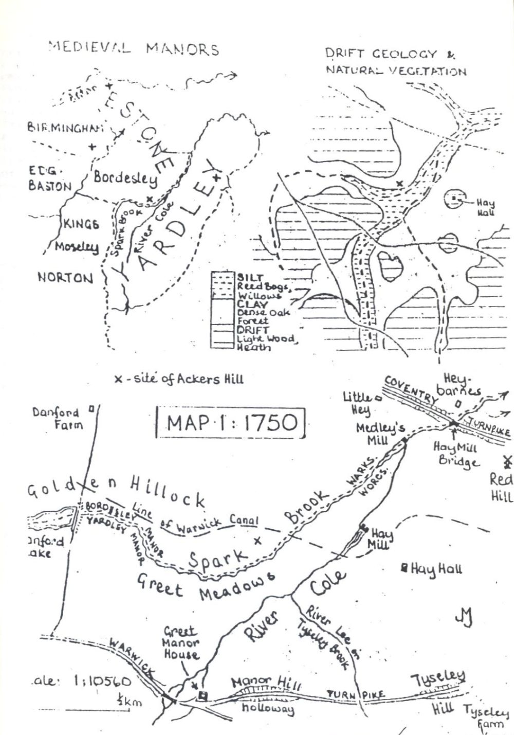
The Manors
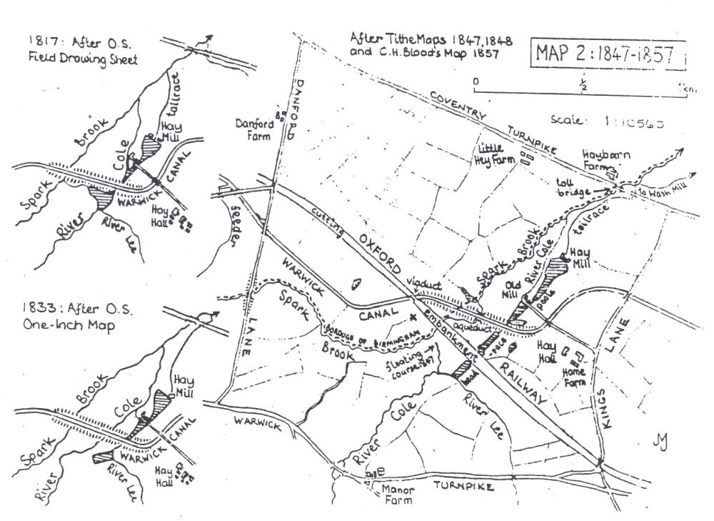
The Warwick canal
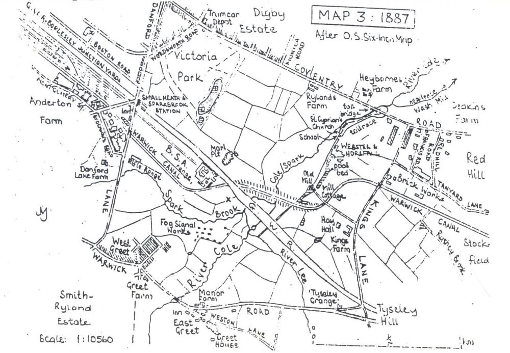
Railways
Industry
Ackers three
Urbanisation
Parks and open spaces
Churches and schools
The Ackers leisure park
Itinerary
Maps