 Acocks Green History Society
Fox Hollies Road
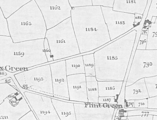
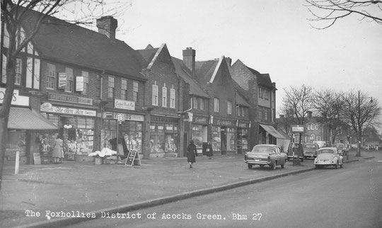
For the purposes of this page, we are looking at Fox Hollies Road from the Warwick Road to York Road on the odd-numbered side, and on the south side from the Warwick Road as far as the track alongside Ninestiles school, i.e. using the old Ninestiles path line as the border with Hall Green. Fox Hollies Road was known as Hall Green Lane for a time. It includes Acocks Green's third shopping centre after Victorian Warwick Road and Edwardian Yardley Road. This centre is inter-war in its development, and associated with the massive growth of municipal housing nearby. The other major historical site is Fox Hollies Hall.
At the time of the Tithe map, in the 1840s, there was a small cluster of buildings at the north corner of the junction with the Warwick Road. The Parkes family were here. When the land came up for sale in 1876, 47 acres of it, the house was occupied by Abraham Hopkins, a wine and spirits merchant. He had been there since at least 1861. The property was called Kitts Green House in that year. There was a barn and there were three cottages as well. Between here and Fox Green, there was a six-acre smallholding rented by Richard Edwards. He was a 'gardener', so was probably growing vegetables and fruit rather than cereal crops. He had a housekeeper and servant living with him. There was a stable there as well. He was there in 1851 as well as 1841. The 1888 directory has the Birmingham Woven Wire Mattress Company in existence at the corner. The proprietors, Messrs Waterhouse and Blantern, converted their partnership into a limited Company in 1895. The factory was called the Pioneer Works by then. Later they made furniture. The business was put up for sale in 1933, but the factory was still there in 1937. Intriguingly, in 1939 the Corporation proposed to build a public swimming pool at this corner, and another in Stechford, but the Acocks Green pool was not built until over forty years later at another site. Instead prefabs were built at the corner in 1945, on the Warwick Road and five on Fox Hollies Road, numbers 5-15 (no number 13!), and they lasted until c. 1965. After they were removed, new council blocks replaced them, one of three houses, and another of two, together numbers 1-9, also with some housing on the Warwick Road. However, these new builds were not at the corner but away from it, leaving an open green area, probably for road junction improvements. These finally materialised in 2001, but did not remove the green area.
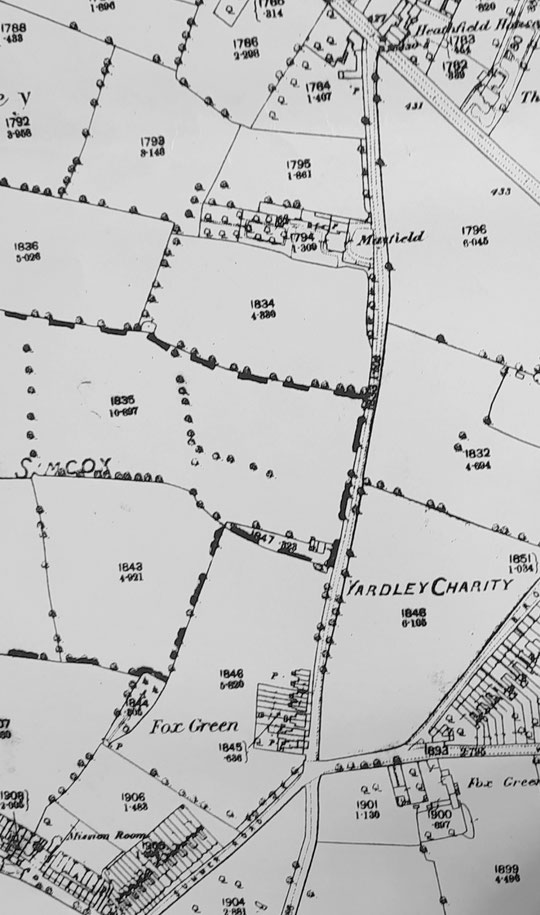
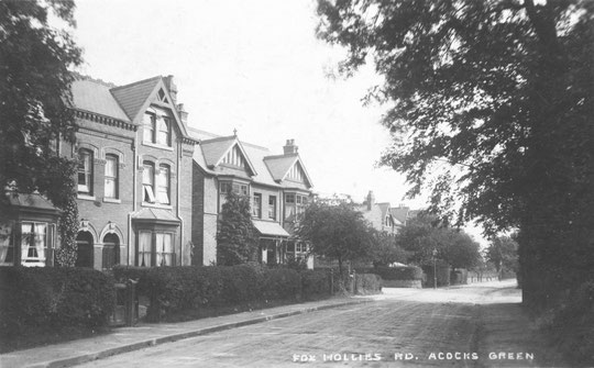
Numbers 19-23 are three council houses dating from c. 1926, as are numbers 25-35. number 37 is a small house in the front of the grounds of number 39. it was built as a lodge for number 39, and was on the 1901 census as Mayfield Lodge. This much larger house was probably built in the late 1870s and in 1891 was occupied by James King, a cabinet maker. The house became known as Mayfield, and lasted as a private home until the mid-1930s. At this time, something rather special happened. The Lady Mayoress from 1934-6, had been concerned that Gentlewomen, in other words educated middle-class ladies, might be living in poverty when retired, and that there was no housing option other than an institution. So she and her husband bought Mayfield, and turned it into the Lady Mayoress House, the first old people's home in Birmingham. It opened in April 1938, catering for 16 residents, who had their own room and access to a communal lounge and dining room. Initially they were looking for ladies aged from 55-70, but that later became 60-70. The ladies paid a small amount each for their room and services, but there were constant appeals for donations to make up the funds required. The house was renamed Grey Gables in 1944 to honour Mrs Jessie Grey, who died in 1960. Despite the funding problems, the increasing demand for such accommodation led to more appeals to fund extensions and improvements, for example a lift in 1961, a two-storey extension in 1966, and in 1967 for more building to increase the number of residents from 21-27. In 1973, they appealed for £130,000 to fund a further increase, now to include men. A frail ambulant wing opened in 1976. Another small extension was passed by planners in 1982, and one for nine rooms in 1986.
Numbers 47-69 are municipal housing from c. 1925. After Mayfield Road, numbers 73-109 were there by 1911. Numbers 111-121 are dated 1908 and have the name Park View. Number 123 may be part of the site of number 125. The private inter-war semis from number 125 to number 143 date from c. 1926. There are no numbers 145-153.
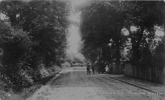
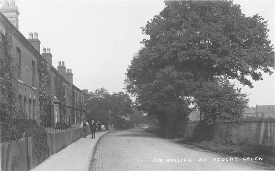
Numbers 155-185 make up 16 houses in groups of four. Numbers 171-185 are on the 1888 map. Numbers 187-9 are a pair, also on the 1888 map. Numbers 155-161 do not appear to have been a named group. Numbers 163-169 were called Albert Place. They must be later than 1886, the survey date for the 1888 map. Numbers 171-77 were called Herbert Place. This name appears in the 1886 directory. The group is on the map, but without garden boundaries drawn, so just built. Numbers 155-177 were all owned by members of a family called Harris in 1912. Numbers 179-85 were called Fox Hollies Cottages. They also appear in the 1886 directory. Numbers 187-9, a pair, were known as Malvern Villas.
Numbers 191-5 are no longer there. They were demolished c. 1974, and a large hoarding stood there in 1980 and 1990. The area is used for parking by the bus garage. Number 195 was a shop, and a shop is listed at Fox Hollies Road in 1880, occupied by William Brooks, baker. Perhaps the business moved to Broad Road from there. The 1881 census has eight listings between here and Mayfield, so it is possible that numbers 191, 193, and Fox Hollies Cottages were there then.
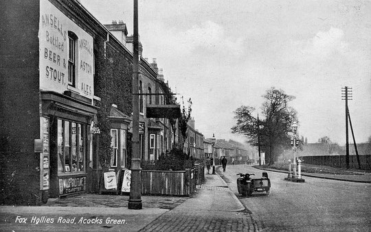
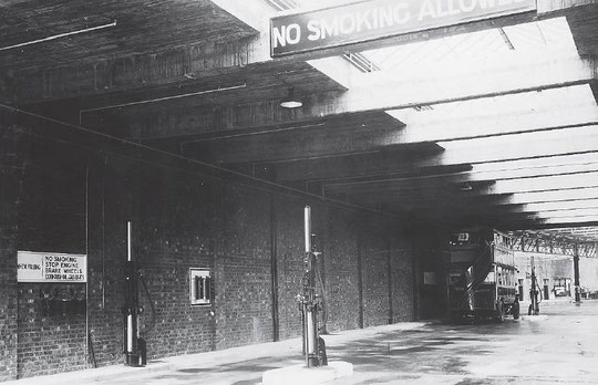
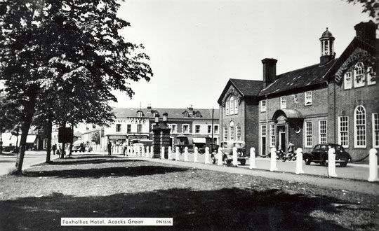
The shop's owner in 1894, Thomas Parsonage, died, and his effects were sold. In 1901 William Stone was there as a grocer and shopkeeper, but the property was owned by Rushton's Brewery. In 1911 Harry Forrester was at the shop. He had beena Rushton's tenant elsewhere. Rushton's also had the New Inn at the Green. They were taken over by Ansell's in 1923. The postcard below from c. 1930 shows the property as an off-licence. It was also a shop. This is listed in 1970-1 in the directory, but not in 1973-4. Fowler's Forest Dairies were listed at number 191 from 1925 until the early 1950s. They also used a site on Westley Road, both probably for storing carts/vans and horses. The bus garage opened in 1928. It is perhaps best known as the home of the Outer Circle route. it has been Europe's longest bus route since 1926, apart from a short period from 2013 to 2016 when Coventry created the 360 route: they then split it into three.
The filling station appears to date from c. 1969. The land had been part of the Fox Hollies pub site. An office and shop were added to the garage c. 1980. Lidl opened in 1999, two years after the Fox Hollies pub was finally closed down, after failed attempts to give at a new lease of life after its first closure in 1992.
Crossing the last stretch of Olton Boulevard East, a dual carriageway because it was planned to be part of an Acocks Green bypass, we come to inter-war shops. The corner block dates from c. 1931. At number 287, the angled shop at the corner with Olton Boulevard East, a branch of the Lynex Joke Shops opened in November 1979. Apart from fake blood, the shop offered such delights as a traffic warden voodoo pin cushion, and revenge kits including hot sweets, itching powder and sneezing powder. They served 753 customers on the first day!
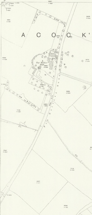
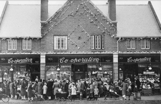
The former Co-op branch number 100, now numbers 295-9, opened in 1929. Numbers 301-13, a block of seven shops with gables, dates from the late 1920s. The next block, with flats above, numbers 317-33, dates from c. 1955. Behind this block is Hall Green Little Theatre, built entirely by volunteers from 1950. Curtis Gardens, the official name for the parkland next door, is the site of Fox Hollies Hall and its grounds. This whole site was earmarked to be parkland after the house was demolished in 1937, but in 1959 the back of the site was reserved for three tower blocks, with wartime allotments and prefabs being removed. More land was taken for garages with flats above, a community hall, and a Training Centre, later Fox Hollies Special School. Three bungalows, numbers 413-7, are between the parkland and what became a new build Children's Centre in 2008. Number 433 is a Dare's detached house from c. 1949. numbers 435-45 are inter-war municipal from c. 1929. Finally, on the other side of York Road, is the York public house. It opened in November 1931. Locally LIsted Grade B, there is currently a planning application to turn it into a hotel, with a new block added.
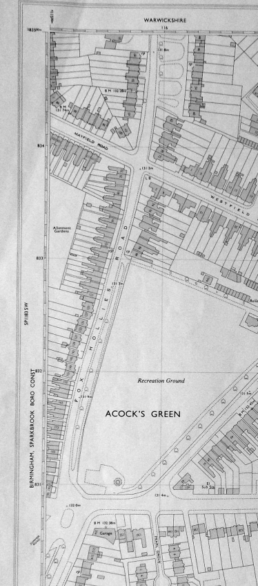
ON the even-numbered side, numbers 40 to 60 date from c. 1926. Numbers 62 (Woodside), 64 (Lyndhurst), 66 (Graham House) and 68 (Hazlemere) date from 1891. Numbers 70-72 (The Hawthorns and Flamville) were built c. 1905. Number 74 (Oscott), 76 (Raglan), 78 (Matlock House), and 80 (Clevedon) date from 1891. Number 82 (Holborn), 82 (Beauchief), 84 (Shaldon) and 88 (Norham, date from c. 1905). Next is the Recreation Ground. The developer of the eight 1891 houses sold them on in 1893.
On the other side of Westley Road, number 204 was there by 1940, and was a cafe/restaurant until 1955, when it became a Regent petrol station. Competition came just over the road from the Merestones garage c. 1969, and number 204 turned to selling cars by 1986. Numbers 212-4 date from the early 1950s, and numbers 216-226 from c. 1926. Numbers 228-30 began as a constructional steel and iron work business around 1930. It was surrounded by houses, and was at times an unloved neighbour, in its later days hiring out skips. Around 2008, the house itself was partly converted to a day nursery. The commercial area behind was sold and replaced by housing, Hazelwood Gardens, completed in 2020. The block comprising numbers 234-6 is municipal and dates from c. 1954. Number 240 dates from c.1928, and number 242 from c. 1926.
Between Hazelwood Road and Olton Boulevard East stands an unattractive 1960s block. This replaced a 19th century house occupied by the Edmonds and Moody families, the house being known as Clifton House. The Edmonds came to Acocks Green after retiring from running the Black Swan in Bromsgrove Street, and Robert Bruce Moody died in 1880. Sarah Edmonds, by now a very old lady, continued to live at Clifton House until her death in 1907. By then her daughter Clara Bruce Hodges was living with her. She was a widow, and had run the New Inn Hotel across the road from the Black Swan with her husband Charles and later on her own until c. 1904. She died at Clifton House in 1910. Sarah's other daughter Eliza had married Robert Alexander Moody in 1863. By 1911 Leonard Bruce Moody, son of Robert and Eliza, was in residence. The house was still owned by Sarah's executors. He was a foreman overseeing the manufacture of gun components. Eliza was living with her daughter Elsie's family in Sparkbrook when she died in 1915. Leonard died in 1933. His wife Evelyn was still at Clifton House in 1957, but when she died in 1960 she was living in Olton. The estate came up for sale in 1960, with planning already in place for a flat block.
On the other side of Olton Boulevard East stand a set of 1930s shops with two floors of accommodation above. Numbers 268-80 were listed in 1935. Adjoining are numbers 282-300, which were listed in 1936. Number 302 was added onto the side of number 300, possibly in 1984, and became a dental laboratory in 1993. Number 304 was listed as a shop in 1935, and numbers 308-326 and 354-374 appear in the 1936 directory, as do numbers 398-400 on the other side of Hartfield Crescent. Numbers 308-400 are Dare's houses. Number 402 was there by 1930, according to a directory, and looks like a Dare's house. Number 404 was built as a bungalow by 1930, but was demolished around 2005 and replaced by a pair of semis, numbers 400 and 400A. Numbers 404-8 were listed in 1922, and numbers 410-16 were listed in 1927. At this point the old Ninestiles path crosses. Down here was the YMCA grounds.
The YMCA bought fourteen acres freehold in 1913-4, and used the land as a sports ground. In 1931 they built a brick building there, the first on a YMCA site. They also built a meeting hall, and the O.S. map surveyed in 1937 shows that the site had two pitches, tennis courts and a pavilion, with the path running through the centre of the site. In 1940 they agreed to give half the site to the city for allotments, but then the Ministry of Supply wanted to build a factory on the site. After local opposition, they went elsewhere. In 1941 the YMCA opened a youth centre, in 1943 the club premises were extended, and they ran a wartime static canteen there. They sold the remaining land to the city at the end of 1962. However, the allotments already owned by the city were upgraded after the war. According to a newspaper article in July 1951, there would be communal rose beds and shrubbery, trim grass verges, permanent concrete buildings, and properly laid roads. In 1953 a clubhouse, store and lockers were received. The site was described as Birmingham's "First Model Allotments".
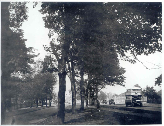
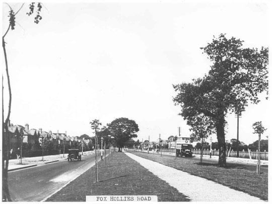
Fox Hollies Road in Acocks Green was a narrow lane until 1930-1, when it was widened as far as the Recreation Ground. Around 1962 the speed limit was raised to 40mph. From 1988-1991 there was concern that the road might feature in an upgraded link from the new M40 into the city centre. In 2000 there was a suggestion that the speed limit be cut to 30mph because of the number of accidents. What happened was pedestrian traffic lights at Greenwood Avenue. In 2003 a new pelican crossing was inadvertently made too near to Westfield Road: the solution was to ban left turns from Westfield Road into Fox Hollies Road. Of course in common with many other dual carriageways that might have been seen to be designed for 40mph, Fox Hollies Road is once again a 30mph limit road.


The National Library of Scotland website has 25-inch maps up to the 1930s, and 1:1250 and 1:2500 maps up until 1973. There is also an option to compare Edwardian and current maps of various kinds using a slider. For this use the geo-referenced maps option. This is useful for plotting the exact location of changes.
Return to AGHS Homepage