 Acocks Green History Society
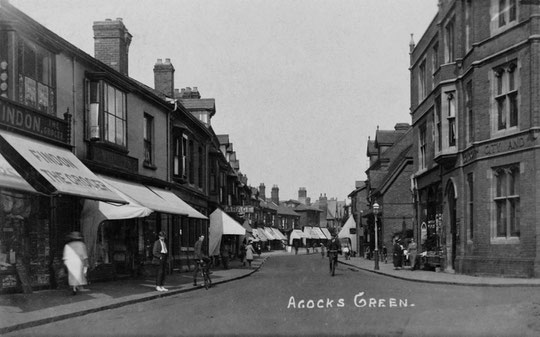
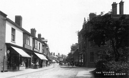
Warwick Road, north side, Stockfield Road to Station Road
We start by looking at the north side of the road, from the opposite side of Stockfield Road. Where the car dealership is now, a Congregational church stood until c. 1973. This was built in 1860 for a number of the wealthy businessmen who were amongst the pioneers who changed Acocks Green from rural to high-class suburban. The church was extended in 1895, and carried on until 1956, when it was sold to another religious group.
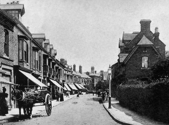
The first building on the north side east of Stockfield Road is a house called The Lindens on the 1888 map. Later it was known as Firsgate. The 1861 census has only one name of a well-off person before Flint Green Road, namely John Williams, glass manufacturer, but the 1888 map has three large houses, and in 1871 there are four names here: Richard Clarke, land agent; Walter Graham, merchant-colonial; Joseph Lee, retired farmer, and John Beddow, scale beam manufacturer. Joseph Lee is at Heathfield House, the middle house, in a directory of 1868, and John Beddow is at The Elms, the third house at that time. There is therefore a chance that The Lindens was there by 1871, but not with that name. It could, of course be earlier. By the 1916 map, a fourth house, Hillcrest, just west of The Elms, is present. This is in the 1908 directory. All four houses are in the 1930 directory. However, two will be demolished within a few years, namely Firsgate (old number 924) and Heathfield House (old number 928). Four shops, numbers 902-908 at the Stockfield Road corner, date from c. 1934. Semi-detached houses from there (numbers 910-940) are from c. 1934 as well. Number 910 was a dental surgery by 1940, and lasted as such into the mid-1960s. Hillcrest, by now number 946, still stands, as Arden Lodge Residential Care Home, and has a blue plaque commemorating John Curry, the ice-skater. At the rear is located the office of a private school offering specialised teaching. It has four small sites in Erdington. The Elms became number 948. This is now a children's home. In 1925 it was the home of Taplis and Holland Ltd., public works contractors. By 1940 it was a district nursing branch of the City Council. In the 1970s it became the Council's Warwick House Short Stay Unit. For a while, The Elms had been home to Arthur Holden, varnish and paint manufacturer, whose daughter Edith became famous posthumously in the 1970s as the author of the Country Diary of an Edwardian Lady. The family was at The Elms from some time in the 1870s to c. 1882, according to directory and 1881 census listings. Edith was born in 1871 in Moseley, so The Elms was a childhood home. Her father was listed in Moseley in the 1871 census, but there is an Arthur Holder at the Elms in the 1876 directory (a misprint?). Edith is actually famous for her connection with Olton. She married a sculptor called Smith in 1911, lived in Chelsea, drowned in the Thames in 1920, was apparently cremated in Golders Green, and was buried in Edinburgh.
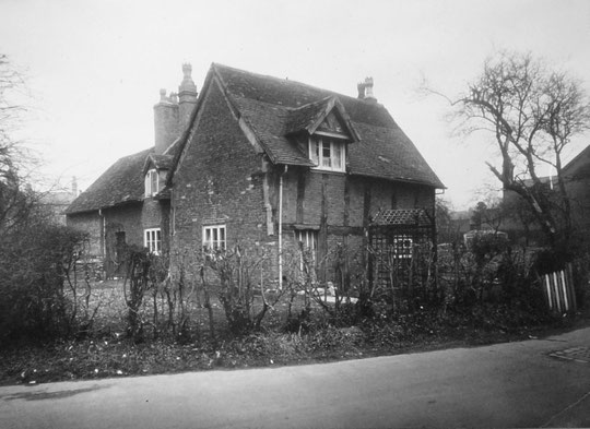
The next group is numbers 950-960. Five of these are on the 1916 map. They had names for a while: 950 (Brynbella), 952 (Stewarton), 954 (Cambrae), 956 (Jeanbury), 958 (Parkstone), and 960 (Glen Lyn). The last two were built first, if the directories can be relied on. Numbers 962-980 are Williams and Boddy houses, in the same styles as Arden Road, part of Greswolde Park Road and part of Flint Green Road. They also originally had names: 962 (Farnham), 964 (Enville), 966 (Dereham), 968 (Coundon), 970 (Birchill), 972 (The Hollies), 974 (Boscombe), 976 (Brecon), 978 (Dalmeny), and 980 (Lynton). The last two are earlier, and are on the 1904 map ? earlier d, not on the 1901 census. After Greswolde Park Road are earlier Williams and Boddy houses: 982 (Cottesmore), 984 (Uphill), 986 (Rawdon), 988 (Ben Rhydding), which are on the 1904 map, and 990 (Ennerdale), 992 (Eskdale), 994 (Grasmere), and 996 (Ambleside), which are in a 1900 directory and could therefore be 1899. Grasmere and Ambleside have name plaques but no small windows above the doors. Numbers 998-1010a look like 1950s maisonettes. There used to be a half-timbered cottage at the corner of Flint Green Road, and the maisonettes occupy the site of the building and the open grounds to the west, as well as a short stretch of Flint Green Road. Across Flint Green Road farm buildings and charity cottages stood (Yardley Great Trust), which were replaced by houses numbers 1012-1018 by 1935, and by the next group of buildings, c. 1950 flats/maisonettes, which are a curiosity in that they are at an angle to the road. The 1871 vicarage for St. Mary’s, which stood next door, was abandoned in 1974 and the land sold for council housing. The vicar went to a house on Dudley Park Road.
St. Mary’s church was built in various stages from 1864 to 1903. The last buildings before Dudley Park Road (numbers 1052-1056) date from c.1924.
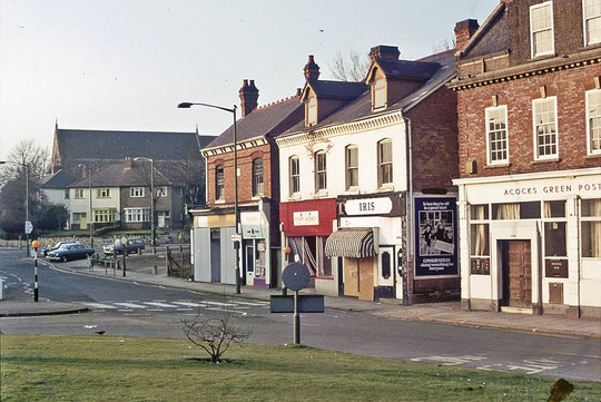
Numbers 976-8 (Greenway House) and 990-2 (Pathway) are used by the Urgency Housing Organisation (established 2002), offering supported living to 16 to 21-year olds. They also have a site at 39-43 Broad Road. 978 had a doctor in residence in 1945, but by 1956 it was the Greenway Commercial Hotel. 980 became a hotel c. 1986: after a few years there was an application to use it for residential business training. By 1994 it was the Greswolde Park Hotel, which gave way to an Indian restaurant c. 2013, called Little Havana rather strangely for a while, then (New) Punjabi Rasoi. 982-6 may have had a period as a care home from c. 1984 and then again from 1996 after being a hotel, as Elliott House. 982-4 were a hostel for Sifa-Fireside by 2009, and in 2019 are run by Trident-Reach. 982 has been named Tenchlee House. Extensions were planned in 2004. From 1997-2000 numbers 990-2 became Boss Hogg's hotel/restaurant. 990 was also La Guillotine restaurant at one time. 994-6 were also part of the hotel that been at 990-2 since c. 1990 for a while from c. 1996, but they were sold in 2001.
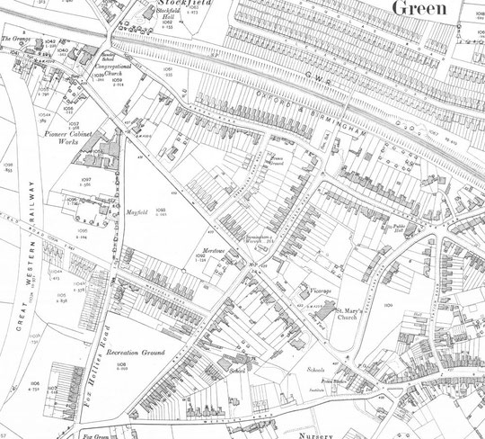


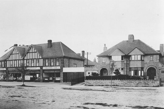
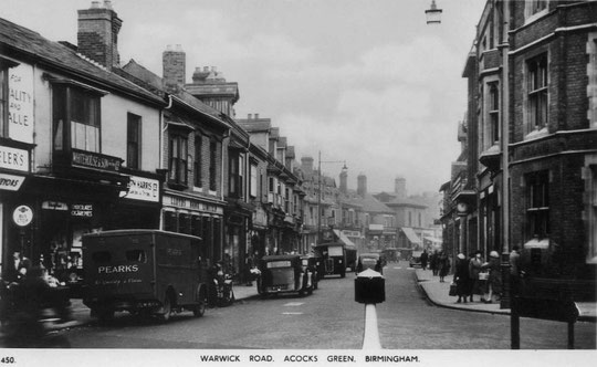
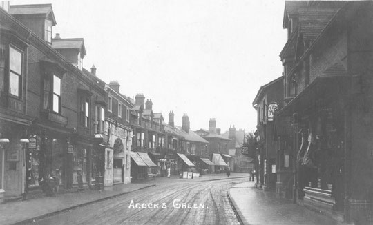
From Dudley Park Road to Station Road there are shops, the current orange set plus white tower dating from 1973-6. They replaced a row of Victorian and early 20th century buildings. The 1888 map, surveyed in 1886, shows that not all the older shops were there by then. There was a group of nine, from what used to be the Wool Shop (1076) to Leston’s Outfitters (1096) or perhaps 1098, and a building at the corner of Station Road. Numbers 1062-1074 were not shown there, neither were numbers 1098 (?), or 1100, to 1108. A builder, Crescens Smith, is listed. A house, later 1084, which was subdivided into three units eventually, was theirs. It is possible that the single storey buildings to the left of here and the wooden edifice next to the brick house/shop were originally part of the building business, except that there was a bakery listed west of Smith in the 1891 census sequence (Joyner), which would probably have been the long angled building. The 1884 directory lists Martin the pork butcher, Harris boot and shoe, Brown the draper, Frost the chemist (a Post Office as well in 1896), Thornton the fruiterer and poulterer, making six further businesses. The Metropolitan Bank of England and Wales is a new name in 1892, possibly in a new row numbers 1100-1108. It would be curious if some of the 1884 names now identifiable in this row in 1900, namely Brown, Frost and Thornton, had not moved into the new shops, making way for others who appear in 1896 in the earlier shops, namely Grindley the tea dealer, Wright the draper, and Bourne the greengrocer. It is feasible, therefore, that 1100-1108 date from 1891-5. Martin the pork butcher was in the middle of the 1886 map row in the 1891 census sequence, but was in new premises at Brook House (1066-8) in the 1900 directory, so may have moved there in the mid-1890s. A new Post Office was listed in 1896 at the western end of the row, 1062, run by Bordeaux.
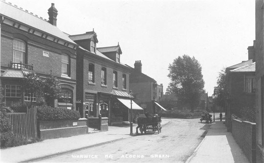

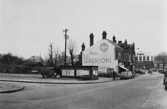

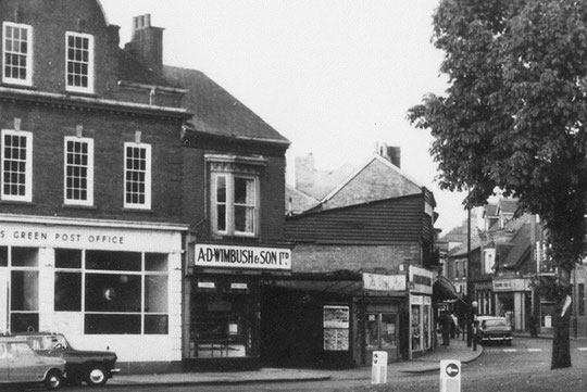
The row was filled up by 1900, with the exception of the 1914 shop and Post Office building at 1070/2. Part of the Post Office at 1062 became 1064, hairdressers, after the Post Office moved a few doors along in 1914, but initially only occupying half the frontage of the building (1072). 1066 and 1068 were a pair. 1066 was Martin’s pork butchers for over half a century. The building was initially known as Brook House, because the Westley Brook flows underground to the side of the building. At first the butcher appears to be in 1068, with a cycle maker (Martin and Law) in 1066, but later 1068 was a grocery business. It was actually Acocks Green’s first Co-op branch (known as the Birmingham Industrial Co-operative Society until 1925) from c. 1910. The former Post Office at 1062 was also a BICS branch from around the same time, a bakery, which was later a Wrensons branch. 1070 was a draper (? 1914, 1920), gown shop, wine and spirit merchant until the post office was refurbished and enlarged in 1935. 1074 appeared well before the Post Office, being a confectioners in 1900 (Giles, later Grindley, and Trillo), and was a Wimbush branch from the mid-1930s. Maybe one of the reasons there had been a gap in the buildings is because the Westley Brook flowed underground here. The number 1070 was at times used for the various engineering businesses behind the shops.
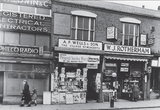
We have already referred to the low buildings west of 1084, which were later well known as the Wool Shop (1076), Gilbert’s boot and shoe, and an electrical and radio business (Baldwins). 1076 had been a toy shop, a flower shop and a gas fitter’s premises (Newman). 1080 was later a carpet shop. 1084 had three windows in the first floor, and eventually was home to three businesses: Wells newsagent (1082), a tobacconist (1084: Bruce, Rotherham) and Owen’s hardware (1084A), later a Singer Sewing Machine shop, following a period as Smith’s hardware store as 1084. In 1881 there were three unoccupied premises from there, then a draper, an eating house and a grocer. In the 1884 directory Martin’s pork butcher was in this row, as were Harris (boot and shoe), Brown (draper), Frost (chemist), and Thornton (fruiterer and poulterer). There is perhaps a possibility that these are in the later row 1100-8, but they would surely have been on the map surveyed in 1886 if that were the case.
The next building had four first-floor windows, the central two being bays. Sometimes three businesses were listed, sometimes four. Wright’s Fancy Bazaar, Grindley grocer, Harris dyers, Findons grocers and Wrights drapers were later replaced by Pearks Dairies, Wheelers butchers, Whitehouse confectioners (later Birmingham Dairies) and Harris dyers again. 1086 was Pearks until the 1960s (followed by Barclay’s Bank) and 1088 was a butchers from c. 1935 until the 1970s (Wheeler). Then came 1090 and 1090A by 1925. Previously it had been a drapers (Wright) from c. 1896. This was a confectioners (Whitehouse 1940s and 1950s) and a cleaners and dyers (Harris). Next door was a building which became Lloyds Bank (1092-4) (1908 directory), which may have been a tailors and confectioners before (Moore). 1094 appeared to be residential in 1930 and 1940, probably for a caretaker for the bank. 1096 and 1098 were for many years Harris boot and shoe (until the 1960s) and Walkers cycle manufacturers and later garage. From c. 1930 1098 was Taylor’s cash chemists, later Timothy Whites.
AS regards the last row, 1100-1108, in the 1911 census, 1102 was listed as Leicester House (confectioner), 1104 as Marlborough House (draper), 1106 as the Green Pharmacy, and 1108 as Hereford House (butcher). 1100-8 had a tobacconist (Bruce), a confectioner (Whorwood), a draper (Brown), a chemist (Needham) and a poulterer (Daw) in 1925. Of these, 1102 was a Co-op butchers by 1930, and 1106 a Co-op grocers. 1100 was a Co-op clothes shop by 1935, and 1106 was a Co-op grocers by 1940. 1108 It was a fruiterer (Hill) in 1904, then later was home to Daw’s poulterer business. It was a wine and spirit dealer by 1935.
At Station Road, a silent cinema appeared in 1913, which lasted until the Warwick cinema on Westley Road (a “talkie”) opened in 1929. This replaced the Bridges' building and grocery business, Bridges being listed at this location from 1888. The building was still there in 1934, but was knocked down and the long site, stretching up Station Road, was occupied by Payne’s shoe repair shack for thirty years from c. 1940.
The new 1970s number 1076 became the short-lived home of HSBC in 2000 after they abandoned their premises at the 'Bank Building'. 1078 became a dental surgery in 1999.


The history of the Warwick Road in Acocks Green
North side of the Warwick Road, Stockfield Road to Station Road
North side of the Warwick Road, Station Road to Lincoln Road
South side of the Warwick Road, opposite Stockfield Road to Westley Road
South side of the Warwick Road, Shirley Road to Olton Boulevard East
The National Library of Scotland website has 25-inch maps up to the 1930s, and 1:1250 and 1:2500 maps up until 1973. There is also an option to compare Edwardian and current maps of various kinds using a slider. For this use the geo-referenced maps option. This is useful for plotting the exact location of changes.