 Acocks Green History Society
Warwick Road, north side, Station Road to Lincoln Road
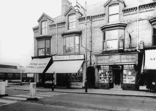
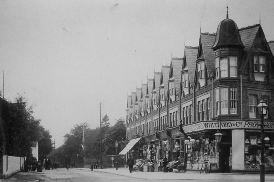
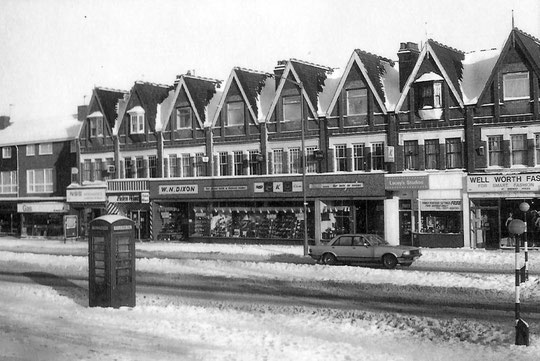
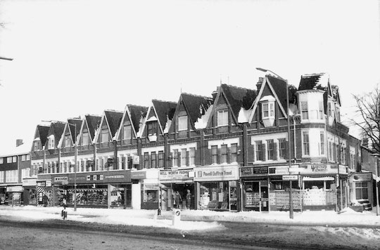
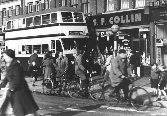
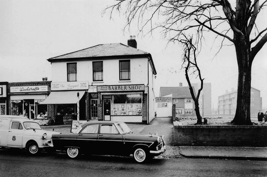
From Station Road, only some of the older buildings were built as shops. The first four shops from the corner were built as Excelsior Buildings. George Lucas, baker is in there (1114, later Ernest Harding) as such in the 1888 directory and 1891 census, as is Harry Patterson, a butcher (1116). The next two shop premises are not listed in the census, but that does not mean they were unoccupied as shops. The next buildings listed are Holly Cottage, which was residential in 1891, and Holly Villa, also residential then. However, in the 1900 directory and on the maps, there are four businesses after Patterson. Ellis (1118) and Hemming (1120), although running different businesses from in 1900, are listed in 1896, and Ellis in 1892. 1118 became a hairdressing salon until the 1930s, when Boots took over. 1120 was a fish shop until c. 1925, when Maypole Dairy replaced that business. Around 1965 Wrights bakers occupied this shop.
Following them are Wilkinson (newsagent, 1122) and Eastman’s (1124 butchers) in 1900, although in the 1901 census only the butcher is there. These two are probably the former Holly Cottage and Holly Villa. 1122 was a newsagent until c. 1925, and 1124 remained a butchers until becoming a fancy drapers c. 1912. These two combined around 1925 unit into one unit of drapers. After the war Timpsons shoe shop and a tailoring business were there.
Myrtle Villa and Glendale come next in 1891. They are listed as residential in 1900. They are later 1126 and 1128. By 1925 1126 was a hardware shop. Next door at 1128 was Freeman Hardy Willis. 1126 and 1128 were replaced by a new building c. 1990.
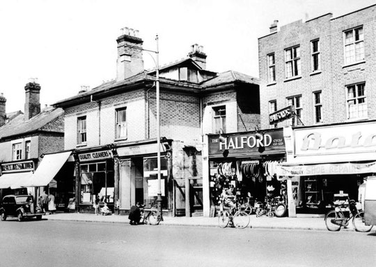
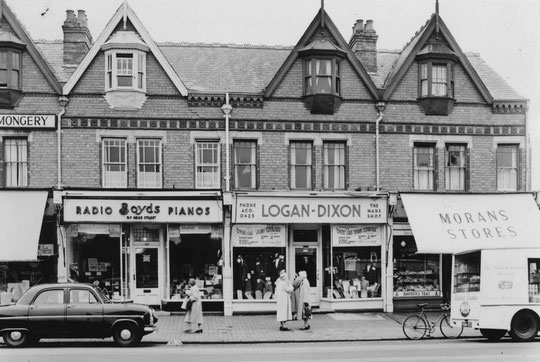
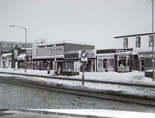
Glendene and Hazeldene were the next pair, residential until the 1920s. They become 1130 to 1134. Both houses had a recessed area at the side. When they became shops these recesses were filled in on the ground floor, and a piece was formed in the middle of the building to create a shallow central shop unit, 1132. 1130 had provisions and cooked meats shops, 1132 was a tea store, a dairy shop, a jeweller, then a cleaners until the 1960s, when a jewellers was to be found there. 1134 was a milliners, house furnishers, then a shoe repair shop (Modern Shoe Repairs), from the 1940s for about 15 years, when it became Bywaters grocers. 1130-4 were replaced c. 1990 by a new build, initially as two shops, but shortly afterwards a third shop front was added.
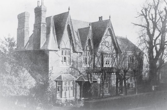
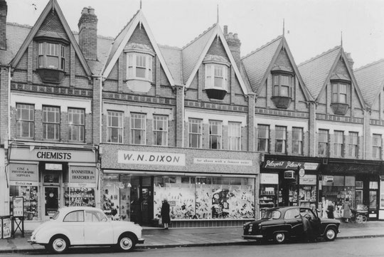
The next house was a more substantial residence, known as Eastbourne House. Gothic in appearance, this is possibly the Dickson’s ladies’ school in the 1868 directory and 1871 census, and 1880 directory. Later the school was listed at Station Road. Maybe it was always there as it is listed at Westbourne Hill House in 1873. Directories do list on main roads if the building is up a side road, especially if the area has not yet been intensively developed. John Fletcher was at Eastbourne in 1876. Another possible candidate for a school there is Henry Martin’s in the 1881 census. Alfred Croad was in residence in 1884 and 1888, Edward Lowe in 1892 and 1896, and from c. 1900 Dr. G. Leonard Hill. By 1910 Eastbourne House was a school, run by the Marshalls. In 1935 the house was demolished and replaced by the then incongruous art deco-influenced block that stands there today. Halfords (1136), BATA shoes (1138), Brighter Homes wallpaper merchants (1140), Dorothy costumier (1142) and Crocker and Son bakers (1144) formed the row.


The next sequence of buildings comprised three more substantial residences, of which one disappeared between the wars, and a fourth set back from the road, which had a short life of perhaps forty years. The first was the Hawthorns, later 1150. It may have been Alfred and Henry Toy’s house in an 1860 directory, in 1864 occupied by Henry Behrens. In the 1870s Thomas Richards(on), and in the 1880s Joseph Fry, a leather factor were there. Pattersons were followed by a cycle manufacturer enjoying the name of Alfred Le Couteur until World War One. Henry Hatherway was followed by Julius Brookland by 1930. Directory entries cease in the mid-1930s and there is a voters list entry for the house in 1935 but not in 1939. The house is not shown on post-war maps.
Next was Westbourne Lodge, latter 1152. This may also date from c. 1860, occupied by a dentist, James Meacham. Ebenezer Preston, a jet ornament manufacturer, was there until the mid-1880s. After Thomas Pedley, an analytical chemist, Alexander Tucker, lived in the house in the 1890s. Edwardian times saw Norman Phillips, but what local people talk about is the doctor’s surgery there. Dr. Ganner was there from c. 1910 until c. 1933. Dr Basil Dain followed. George Perkins lived in part of the house as a kind of caretaker. Despite the 1938 road widening sparing the houses along here, the Council came back c. 1957 to compulsorily purchase the house ‘for road widening’. Dr. Dain went to Victoria Road. Ann Clarke and others have informed us that Dr. Dain kept geese in the garden.
The next house dates from around World War One. It was set back along a tree-lined avenue leading to the boundary of a bowling club accessed from the Avenue. The Grove, or 1156, initially had a Mrs Phillips (maybe to do with Norman Phillips), then Theodor Stokes in the 1920s, and then Harold Stokes and an architect, Hurley Robinson. It was not listed in 1956.
The last of the original three houses was the Limes, later 1160. James Pratt Marrian, a naval brassfounder, was there in the 1861 census, and the name continued at the house throughout the 1870s and 1880s. Joseph Gell followed, then a photographer, John Beaufort from c. 1901. John Archer was there in the 1910s and 1920s, and the last use was as another doctor’s surgery, with Dr. John Allin, later Allin and Colman.
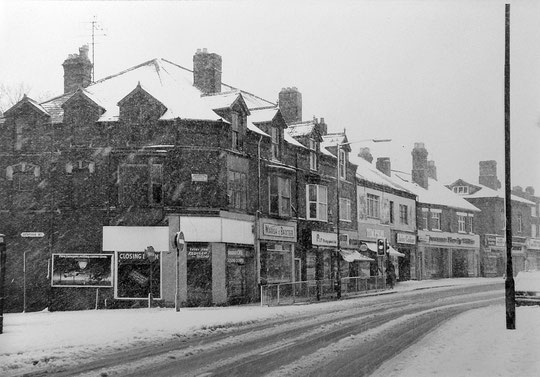
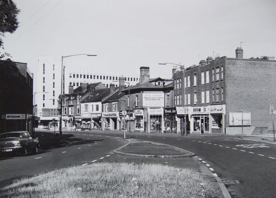
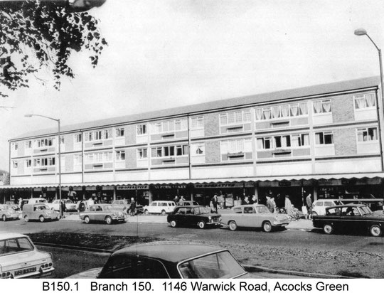
This length of the road was replaced by a long row of shops, a new number 1160, c. 1959-60. To the left of here a Co-op row numbered 1146 opened in 1962, including a supermarket. Wetherspoons came c. 1999, bringing back the name "Spread Eagle". Between the two a new cul-de-sac, Mallard Close, supposedly named after the creatures seen in an orchard formerly there, was made. This consisted of self-build houses. In 1968 a new Holy Souls primary school opened there.
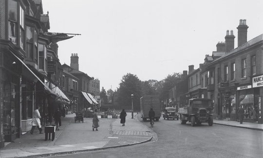
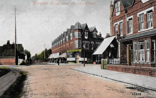
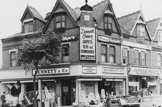
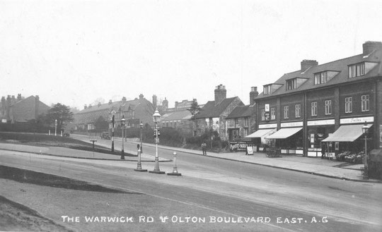
From the rather dull block that is 1160 are once attractive Edwardian shops leading up to Oxford Road. These were built over a few years from c. 1902. The upper stories hint at the original quality, but the ground floors are a hotch-potch of frontages. Well-known names in the row are Tustin’s butchers shop, and a branch of Wrensons. Over Oxford Road, only the corner shop was built as a shop. It was Bishop’s drapers at first. The rest of the buildings up to Woodberry Walk were houses, with maybe a builder’s yard at the end. The houses were originally called Balgownie, Fairhaven, Southdene, and Alveston. They were gradually converted into shops over the next decade, with Dennett’s drapery/furniture becoming the most prominent business. In the 1960s the corner frontage was altered.


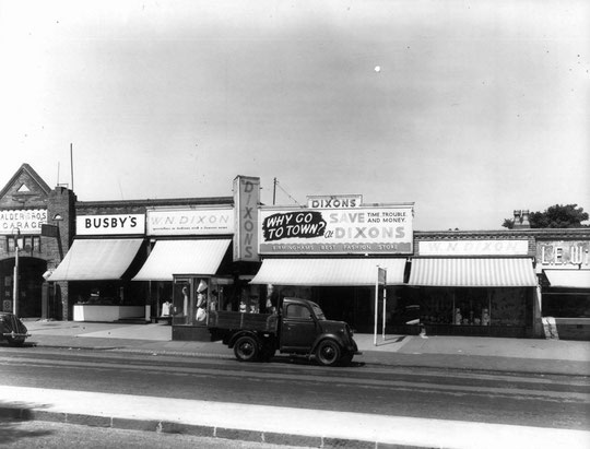
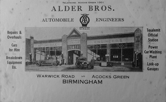
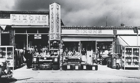
From there, the pieces of land containing the Laurels and Afonwen were acquired by the Alder family, and shops were built. See our page on the Alders for more information.
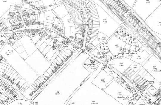
At the time of the Tithe, only one large house was on the stretch to the Parish boundary, and that was Acocks Green House. Before that there were some agricultural buildings, a tollhouse and tollgate, a group of cottages, and then another small group at the bottom of the hill. By 1851 there was a small farm called Ann Aston east of the tollgate, and William Batson, ironmaster was in Acocks Green House. A few years later it was George Wells, a well-known pen manufacturer. By 1860 two residences appear to have been added: Caxton House for a paper dealer, John Benson; and another house in which Joseph Allen, retired printer, was living. The name Ann Aston was still there, but, confusingly appeared to be not in quite the same place. By 1871 Elijah Woodward, an engraver, was in the tollhouse, with his wife as the toll collector. George Hayward was now in one of the two small residences. During this decade Joseph Ash was at Acocks Green House. In the 1881 census a grocer, Edwin Tustin, was in the first house beyond the tollhouse building, while Joseph Allen was still there in the second. By 1891 Acocks Green Farm is the first place listed, with John Woodcock as the farmer, hence Woodcock Lane. The first residence has a new name here: the Laurels, and the second also has a name, Afonwen, where a secondhand bookseller called William Downing was living – possibly an acquaintance of the retired printer who had been living there before. Acocks Green House then had Thomas Carpenter, a gas fittings manufacturer, living there.
The Acocks Green Estate was sold several times during the nineteenth century. There are rent, lease and sale records for 1806, 1807, 1824, 1825, 1828, 1839 (land of 150 acres), 1867, 1894 and 1899. There may be others. The 1839 and 1894 adverts are reproduced below. The 1894 document reveals that Mr Henry Joseph Allwood, who was a dentist and false teeth manufacturer, had an annual tenancy agreement. The house itself was let several times. For more information and photographs concerning the estate and the Alder family, go to this page.
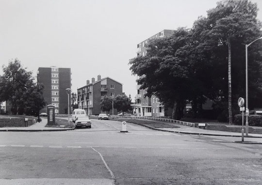
After Acocks Green House was knocked down and replaced by a council estate in the late 1950s (the site appeared on a compulsory purchase list in September 1953, to be used for housing), the old Woodcock Lane name was transferred to the estate road, and the old lane became Woodberry Walk. From the hill down to Olton houses had been built. 1220 is detached, and 1222 to 1240 are semis, and all are there by 1927. A row of semis with a gap in the middle, later filled by Culham Croft appeared c. 1910 (1260-76, and 1278-90). Originally they had names: St. Ives, Brookdale, Sunnyside, Trewyn, Hollowdale, Willicote, West View, Rose Cottage, Glenside, Braeside were half of them. In the 1901 census were Waltham, Bransford and Ferndean, 1292-6, east of which the Acocks Green Laundry appeared by 1902.
Assorted labourers and craftsmen occupied the various cottages between here and Lincoln Road throughout the decades, with one surname, Lancaster, there for many decades. They were carpenters and ropemakers, and their name goes back to the 1840s in documents. They may have been in the old cottages that used to stand between the laundry and the shops at the corner of Lincoln Road. One named building at or by the junction was Rose Cottage. The laundry closed in the 1970s, and after many years the site may be finally used for housing. New shops 1332-8 appeared by 1930, and some of the old cottages remained. They were gone by 1961.
The City boundary runs up the centre of Lincoln Road. It used to be a few doors further east, including 1332-6. The change may date from 1966. A café was listed in the 1930 directory at 1334, and in 1940 a haulage contractor (later a removals company), was listed at 1332. 1336 was a private house at this time. 1332 and 1334 lasted as such until c. 1970. They are both flats now, and outside Birmingham.


The history of the Warwick Road in Acocks Green
North side of the Warwick Road, Stockfield Road to Station Road
North side of the Warwick Road, Station Road to Lincoln Road
South side of the Warwick Road, opposite Stockfield Road to Westley Road
South side of the Warwick Road, Shirley Road to Olton Boulevard East
The National Library of Scotland website has 25-inch maps up to the 1930s, and 1:1250 and 1:2500 maps up until 1973. There is also an option to compare Edwardian and current maps of various kinds using a slider. For this use the geo-referenced maps option. This is useful for plotting the exact location of changes.