 Acocks Green History Society
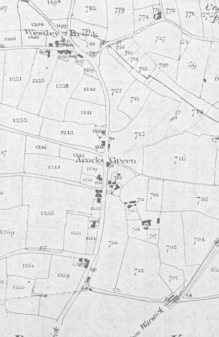
Warwick Road, south side from Westley Road to the city boundary
The centre of Acocks Green was rural and undeveloped until the railway came in 1952/3. Over about twenty years, a row of businesses, with a few dwellings later to become shops, grew to form a row from Shirley Road to the Red Lion. At the Green at the time of the Tithe Map (1843), William Jarvis was renting a property and running it as a shop. There was a house and garden west of the Spread Eagle, then came the Dolphin, and a house, garden and plantation owned by Robert Clift. Then came a short row of cottages, and finally the farm at the corner of Gospel Lane, Beech's Farm.
By 1855 Thomas Harris, shoemaker, was in the directory. He was listed in 1873 between the Red Lion and the Spread Eagle as sub-postmaster, grocer, baker, provision dealer, and agent for Gilbey's wines. He ran the Post and Telegraph Office from there. This was probably east of where West End House is now. Harris was listed in the 1891 census as a grocer and wine merchant.

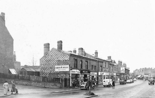
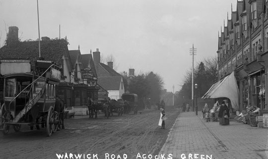
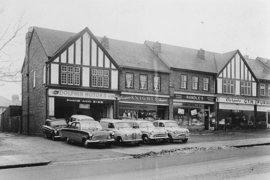
First we will look at the sequence from the Green to the Red Lion. In the 1861 census a butcher is listed after the Green: Charles West. The next entry is for a Stationmaster. Later the two would be owned by George Clifford, who was described as a butcher and farmer, possibly keeping his cattle in the fields behind, where Archbishop Ilsley school is now. The house acquired the name Mossmere, and later was numbered number 1111. It is easy to see that it was once a house for a middle-class person if you look at the upper-storey. So that house dates from c.1860. In 1925 it became the second home in Acocks Green for the Birmingham Municipal Bank, who sold the old butcher's shop next door to the Corporation Gas department. By 1871 there was another very long-lived shop, later number 1119. This was Robert Howle's grocery business. Next came William Gardiner's drapery business, later Manchester House and number 1121, in the 1871 census. The last business listed then before the Red Lion was William Tabberer's chemists shop, later 1127/9. This makes five buildings listed in the row at that time. However, number 1119 is part of a row starting at 1117, and now including three businesses, so both 1117 and 1119 must be contemporary. Also, 1121 is part of a row (1121-9) with two windows either side of a central first floor bay, so the rest of the building must be from that time as well.
In the 1873 directory, Miss Boston, milliner, is listed, and a stationer is also listed next door in 1881. These would be numbers 1113-5, later Lawton's and Jeffery's watchmaking business. Numbers 1131-7 had rather attractive wood ground-floor shop fronts several feet further forward than the front brick walls by 1900. This brought them to the same building line as 1121-9. One name in the 1876 directory corresponds to the 1881 census sequence, Eliza Jones, so this row was there by the mid-1870s. Numbers 1139-43 are there on the 1891 census just before the Red Lion.
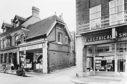
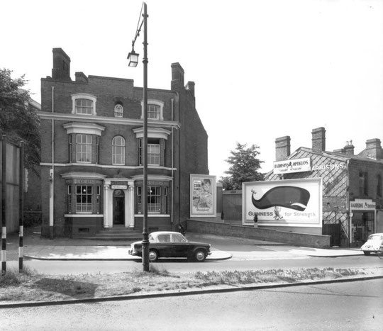
This leaves the 'Bank Building', containing numbers 1101 and 1103, which dates from c. 1901, and is one of the most impressive buildings overlooking the Green. Number 1105 is not listed in the 1911 census or any directory until 1935, when it opened as the Corporation Electricity showroom. This is an Art-Deco-influenced building. The small building filling in the angle between two blocks, number 1115A, is on the 1904 O.S. map, so is probably at least a couple of years older.
The 1911 census sequence has some named buildings in the row:
1101 Bank House, 1111 Mossmere, 1113 Compton House, 1115 Greenwich House, 1125 Manchester House, 1135 the Library. and the last building before the Red Lion is called Cambridge Cottage. In fact all three cottages were called Cambridge Cottage in the 1901 census.
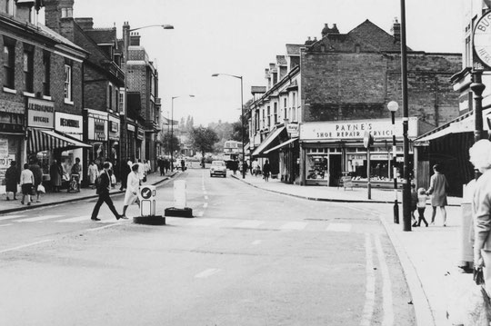
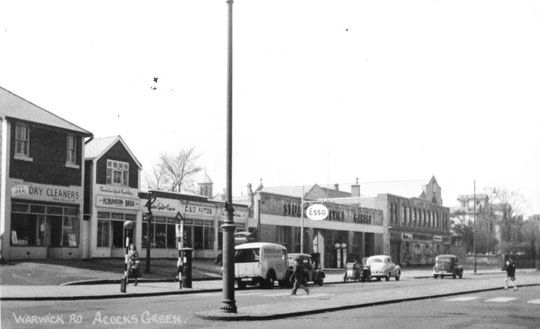
There have been substantial changes to the row since the war. Buildings get subdivided, or joined into one unit, renumbered and rebuilt. The Gas showroom at 1109 was rebuilt c. 1994 after a period as the Anglia Building Society. 1111 (the bank, becoming TSB in 1976) got a new shop front in 1991. 1113-5 got a new shop front c. 2009, 1115A got one c. 1981. There are flats at the rear, which may be conversions of what Halifax did at 1117 c. 1996. 1117 to 1121 were refurbished over a few years from 1999. Everything from 1127 to Morrison's is a rebuild. 1127-9 look like late 1960s or 1970s buildings. 1127 got a new shop front in 2011. 1131-7 could be mid-1960s. 1133's shop front for Iceland dates from c. 1987. Pearks Dairies of the 1960s and Maypole Dairies after them were replaced by Nationwide. The final group of smaller properties up to Morrisons is probably also mid-1960s. This whole group from 1127 is rather undistinguished in appearance.


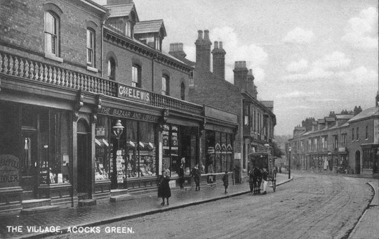


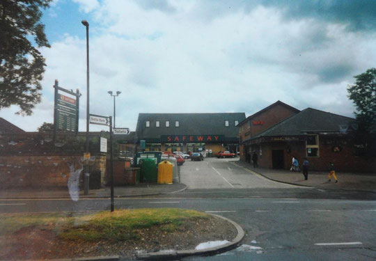
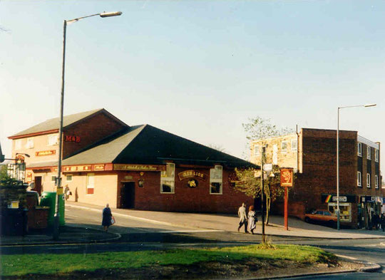
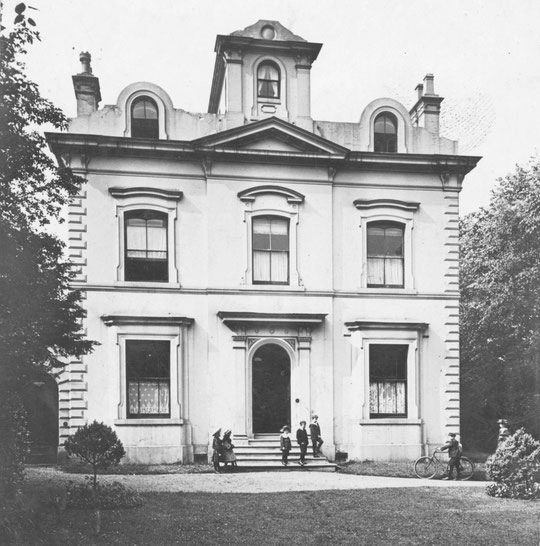
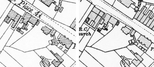
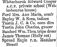
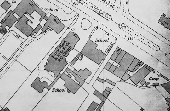
The 1980s Trader/Red Lion has now gone, and the site is part of the car park of the revamped Morrison's supermarket. Until 1982 a Victorian Red Lion graced this spot. The supermarket was originally Safeway. It was opened on Tuesday 22nd February 1983 by the actress Hannah Gordon, the 'Face of Safeway' in the 1980s. The instore pharmacy opened on the Saturday. Morrisons bought Safeway in 2004, then they sub-leased the site here to Sainsburys from late 2005 until 2019. The freehold still belongs to the Catholic church diocese. Previously there was a convent and school between the Red Lion and the Catholic church. They were located in two rather grand houses, Malvern House and the Hollies. The church itself replaced the third grand house, Wilton House in 1925, which had been used until then. All three are listed in the 1861 census. Behind the 1907 Catholic school stands Wellesbourne. It was listed in the 1870s, and in 1885 it became a private boys' school. That closed in 1966. After functioning as a house, it became offices in 1989, and then a church hall in 2013. Next came the home of John Cope, button manufacturer, in 1861, which was called Waverley Cottage in 1871. In 1861 the next building was Thomas Harris's shop, but by 1871 there were three more properties in between: Windsor House, Clarendon House, and Moreton Villa. It is possible that Windsor House was a new name for Waverley Cottage. Both names disappear from directories. In 1905 Mrs Tustin was at Clarendon House, and John Charles Tustin was at Moreton Villa. The postcard below shows the shop fronts in front of these houses, and the side of West End House beyond. Clarendon House was wider, and had two shop fronts. See also the maps from 1904 and 1916, surveyed in 1902 and 1913 respectively, and the 1913 directory sequence. Next door to West End House was West End Cottage. Mr. Banford was a tripe dresser there in 1913, but a cycle dealer by 1918! He was replaced by George Roberts by 1930.
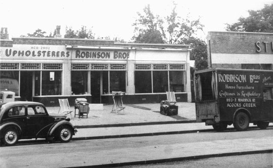
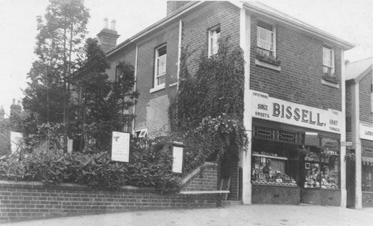
After Thomas Harris in 1871 were William Harris, shoemaker, and Francis Parish at Holly Cottage. Then came the Spread Eagle. Everything up to Victoria Road from the Catholic school was demolished for the late 1920s and 1930s road widening which took place here. A new shop row, West End Stores, was built in 1938 at the new road line. At 1173 Lowe's garage had appeared by 1930. Petrol pumps were removed in 1991. Five shop units (1193-1201) were created by 1933, the last one on the corner of Victoria Road, housing Matthew Bissell's sweetshop. He had been the last landlord of the Spread Eagle. The row had been a long building behind the Spread Eagle with a frontage to Victoria Road. 1193-9 were rebuilt c. 2008. They replaced a motorcycle shop, C. and D. Autos.
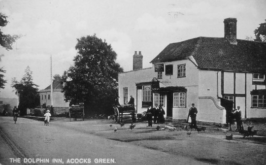
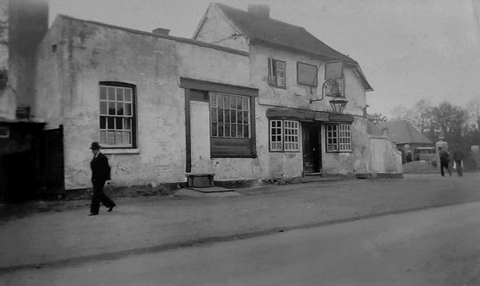
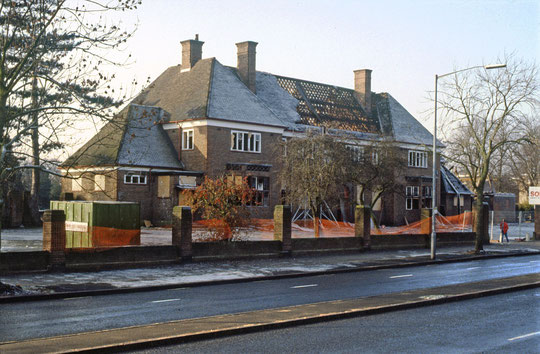
The old Dolphin was replaced in 1930, further back on the site, again because of road widening. It in turn was replaced by the Aldi development c. 1991. On the far side of Dolphin Lane there had been farm buildings and a house with a Regency frontage. These contained Thomas Cliff's malting business. The farm buildings had gone by 1904. The house was known as Ye Olde House, not to be confused with the later use of that name for Acocks Green House across the Warwick Road, when it became a social club. From the corner and over the site of Ye Olde House, a row of shops appeared c. 1932 (1225-37). The rest of the site was occupied by three sets of semis (1239-49), there by 1939.
1225 has always been a fish and chip shop. In 2015 they built a side extension, but did not get permission to incorporate it into the business, and it became a private nursery (1223). 1237 has been a car dealer's or associated business since c. 1950
The next two fields down to Gospel Lane had three labourers' cottages in 1888 in the first one. The second field acquired two sets of semis by c. 1902 (1275-81). These had the names Frondeg, Hillside, Mount View, and Wrentham/St. Botolph's. A little further west a detached house (now 1271) called Carisbrooke appeared by 1904. This was the home of Albert William Boddy. The company Williams and Boddy gave Acocks Green some of its best house designs. West of here 1251-69 have some applied half-timbering upstairs. They date from c. 1910. 1273 is a narrow detached house filling in the gap between Carisbrooke and the next set of houses. 1275-81 have plain facades with bays. 1283-91 have applied half-timbering upstairs, but they are not identical to 1251-69. These also date from c. 1910. House names are on the 1911 census:
1251 Hillview, 1253 Brockley, 1255 Glen Roy, 1257 Kearsley, 1259 Fernhill, 1261 Stonegarth, 1263 Sunbeam, 1265 Broadway, 1267 Pentwyn, 1269 Froome, 1271 Carisbrooke, 1273 Hagley Cottage, 1275 Frondeg, 1277 Hillside, 1279 Mount View, 1281 Wrentham/St. Botolph's, 1283 Glenfield, 1285 Longdon, 1287 Ivanhoe, 1289 East Leigh, 1291 Yew Tree Cottage.
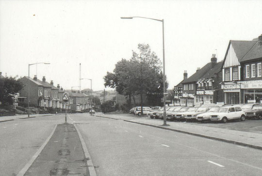
Over Gospel Lane was Redstone Farm, or Beech's Farm. That stood where the triangular roundabout is now. The new road Olton Boulevard East severed Gospel Lane behind the farm in the late 1920s. 1293-5 were originally two buildings in place by 1930 and were replaced by a retail unit c. 1989. This was a wine warehouse and since c. 2008 functions as a pub, Casey Joe's. Next door was a garage, and the boundary went through the middle of the site. It is now divided into a group of four metal box-like units housing a children's play centre, technically in Birmingham but with an Olton road number, and Olton Court, outside.


The history of the Warwick Road in Acocks Green
North side of the Warwick Road, Stockfield Road to Station Road
North side of the Warwick Road, Station Road to Lincoln Road
South side of the Warwick Road, opposite Stockfield Road to Westley Road
South side of the Warwick Road, Shirley Road to Olton Boulevard East
The National Library of Scotland website has 25-inch maps up to the 1930s, and 1:1250 and 1:2500 maps up until 1973. There is also an option to compare Edwardian and current maps of various kinds using a slider. For this use the geo-referenced maps option. This is useful for plotting the exact location of changes.